Tuesday, December 02, 2025
Welcome to Summer / First Bushfire of the Season / Update 7/12/25
Thursday, November 27, 2025
Thanksgiving in Australia
But some communities and families, particularly American expats do.
These celebrations can take place around the American Thanksgiving date or be adapted to fit the Australian calendar ie. moved to a weekend to accommodate work schedules or the Australian spring season.
Interestingly the Australian external territory of tiny Norfolk Island is an exception, as it does have its own public Thanksgiving holiday on the last Wednesday of November.
When the First Fleet arrived at Port Jackson (Sydney) in January 1788, Governor Phillip ordered that a party of 15 convicts and seven free men lead by a military commander to take control of Norfolk Island and prepare for its commercial development.
As early as 1794, the Lieutenant-Governor of New South Wales suggested the island’s closure as a penal settlement as it was too remote and difficult for shipping and too costly to maintain.
The British government began to wind down the second penal settlement after 1847, and the last convicts were removed to Tasmania in May 1855. The island was abandoned because transportation from the United Kingdom to Tasmania had ceased in 1853, to be replaced by penal servitude the UK.
The Pitcairners occupied many of the buildings remaining from the penal settlements, and gradually established traditional farming and whaling industries on the island. Although some families decided to return to Pitcairn in 1858 and 1863, the island's population continued to grow. They accepted additional settlers who often arrived on whaling vessels.
The island was a regular resort for whaling vessels in the age of sail.
The first such ship was the Britannia in November 1793. The last on record was the Andrew Hicks in August–September 1907.
They came for water, wood and provisions, and sometimes they recruited islanders to serve as crewmen on their vessels.
I like the celebration there a lot and just not the huge amount and great variety of food.
Monday, October 06, 2025
Australian Time Zones
The mainland states plus Tasmania normally have three.
There are a few oddities.
Broken Hill in New South Wales chooses the South Australia zone as it’s closer to Adelaide than Sydney.
Both Queensland and Western Australia plus the Northern Territory rejected the concept.
A bit inconvenient especially for those living on the heavily populated coastal region of the New South Wales/Queensland border.
Wednesday, October 01, 2025
Monday, September 01, 2025
Fence Repair After Flood Damage Done (Almost).
We only got about two thirds done before calling it quits.
The area has been electrified off the prevent cattle escapes.
Tuesday, August 05, 2025
Dismantling Vineyard Infrastructure
Monday, July 28, 2025
Preparing for Fence Repair after Flood Damage
Our first priority was the south west corner of the south paddock where the cattle could easily disappear into the bush. With feed at a minimum during the winter they do tend to want to ‘roam’.
Monday, July 07, 2025
An East Coast Low / July 2025
East coast lows (ECLs) are intense low-pressure systems that occur off the east coast of Australia. They bring valuable rainfall to the east coast and tablelands. However, they can also bring damaging storms and cause coastal erosion and flooding.
They can occur at any time of year but are more common during autumn and winter, most frequently in June.
East coast lows often intensify quickly over 12–24 hours. This makes them one of the more dangerous weather systems to affect the eastern coast.
The bureau of meteorology (BOM) was very concerned about the intensity of one forming on the weekend of the 28th June.
They were expecting the cell to impact the New South Wales coast from Monday lasting through until Thursday.
Torrential rain and damaging winds were predicted.
They advised the cancellation of discretionary travel.
Monday night it started to rain here and didn’t stop until Wednesday night.
Rain pelted down.
Over 250mm (10 inches) in 36 hours. 310mm (12.5 inches) in total over 3 days.
Then in the evening the wind got up.
Over 105 km/h (65mph) gusts. Amazingly despite a few light flickers, our electricity stayed on. Others in area were not so lucky. Some had a power outage for 3 days.
Around 10pm, I heard a big bang just outside.
I thought one of our trees had fallen.
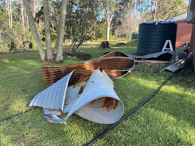
I ventured out onto veranda with a torch and saw that our very old spare metal water tank had virtually exploded. Obviously it couldn’t handle the volume of water going in despite the overflow outlet working ok.
There was metal strewn about the front yard. Worse, 10,000 litres (4500 gallons) of water had been let loose thankfully away from the house.
Next morning, Wednesday, I was up at sunrise to take a look. Thankfully our main tank, plastic, was undamaged.
Our bottom paddock was awash as was the side one. The creek was in full flood.
We assumed the lake our creek runs into was open to the sea as the surf was huge. 8m (25ft) waves reported. So we were hopeful to see the water drain away quickly but it was slow at this stage.
Other places around us were flooded. Our state emergency service were issuing evacuation orders for homes around Lake Burrill.
With the huge surf and high tides, the storm runoff couldn’t get out of the lakes.
They were still doing food drops into the area on Thursday.
Thursday dawned sunny.
I did as much of a boundary walk as I could.
The flooding in the paddocks was gone and despite the creek being back within its banks I couldn’t get over so didn’t know what damage had been done on our southern boundary. It was a very deep fast flowing torrent.
But on the north side of the creek in the southern paddock there was considerable fence damage. Huge logs washed downstream, now left stranded by the receding water, had taken fences down.
Sunday I managed to get through to my southern boundary via a neighbour’s property as the creek was no longer impacting them.
And to my surprise no fence damage. Lots of trees and big branches down however.
Needless to say we didn’t need all this.
Apart from the fencing damage, the paddocks are now saturated. The grass will stop growing and hay for the cows will need to be purchased.
I will need help with repairs which can only start when the water table drops, estimated to be 2 weeks time.
Got to love life on the land.
Tuesday, July 01, 2025
Low Sugar Jam
Sunday, June 15, 2025
The Price of a Cafe Coffee v DIY
Next, there's the milk. A regular flat white typically uses around 200ml of milk. If you're paying $4.00 for a 2-litre bottle, that's $2.00 per litre, making the milk cost about 40 cents per cup.
Additionally there’s the cup and lid, which usually cost around 20 cents together.
Labour is one of the most significant costs in making a cup of coffee.
Consider a full-time, permanent barista working an 8-hour shift from 6 am to 2 pm. The award hourly rate is $27.17.
Adding in superannuation (401k) at 11%, holiday pay at 7%, sick pay at 3%, and workers' compensation at 3%, the total cost to the business per hour is $33.75, or $270 for the entire shift.
If a barista can make 200 coffees during this shift, the labour cost per cup is $1.35.
However, this cost can increase on weekends, reaching around $40 per hour on Saturdays and $50 per hour on Sundays. Therefore, how much it costs to make a cup of coffee can vary significantly based on the day and the number of cups sold.
The gross profit from a cup of coffee involves subtracting the ingredient and labour costs from the selling price.
Assuming a flat white sells for $5.00.
First remove the 10% GST (goods and services tax) which is 45 cents, leaving $4.55.
Deduction of the 98 cents ingredient and $1.35 labour costs leaves final gross profit per cup is $2.22.
Out of that the café then has to pay for rent, power, insurance, and other operational costs like cleaning and garbage disposal. These costs can add up per week. The combination of profit from the coffee and other items sold at the café all have to contribute to covering these expenses.
Monday, May 12, 2025
Australian Federal Election 2025 (25/09/25 Final Update 😮💨)
Voting is compulsory.
The Senate is a state house of review with state Senators enjoying a six year tenure and territory representatives’ tenure tied to the term of the lower house.
There are a total of 76 senators: twelve are elected from each of the six states regardless of population, and two each from the two territories.
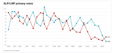
The main contenders for government were the current incumbents, the Australian Labor Party (democratic socialists) and the opposition Liberal National Party (a coalition of urban and rural conservatives*).
There were also a large number of minor parties (30!) eg. The Greens, One Nation plus others and Independents contesting.
It is interesting note how Australia has voted ideologically since 1946.
This time around it was a landslide victory for the Labor Party led by Prime Minister Anthony Albanese.
They won an increased number of seats.
 |
| PM Anthony Albanese |
The conservatives have been decimated.
The LNP opposition leader, Peter Dutton lost the seat he had held for 24 years.
Up until early March polls showed a certain LNP victory.
What happened?
Prior to the 2024 USA election, 73% of Australians surveyed preferred a Democrat presidential victory.
When the USA imposed tariffs on Australian imports despite a trade balance in the former’s favour in April our Prime Minister labelled the US actions as ‘unwarranted’, and ‘not the act of a friend’.
The majority of the population agreed with him.
However Dutton said that if elected he would cut public sector jobs - more than 40,000 by some estimates. This reminded voters of billionaire Elon Musk's DOGE, or Department of Government Efficiency, which has slashed US bureaucracy.
Dutton later walked back the plan but it was too late.
The Coalition even appointed a shadow minister for government efficiency. And images of her wearing a cap with the words MAGA became a key talking point.
Dutton also said Donald Trump is a "big thinker and a deal maker" with a "genuine desire to see peace and stability" in the Middle East after Trump had proposed to "level" the enclave and rebuild a "riviera" under American control.
Shadow attorney-general Michaelia Cash praised Trump as “a man of action”, promising Australians “they’ll get the exact same attitude under a Peter Dutton government”.
Chris LaCivita, Trump’s presidential campaign co-manager, told undercover reporters he advised on ‘structural issues’ related to Peter Dutton.
However the Coalition denied LaCivita was involved in campaign in any way.
But there were other major factors as well.
The Coalition’s nuclear energy policy was toxic to voters, delivering big swings against their candidates in electorates chosen to host reactors, while support for Labor grew in many places it chose for massive offshore wind farms.
It was hoped the LNP would tailor some policies towards women. It was clear it wasn’t a priority.
The policy and messaging on work from home and the failure to acknowledge how hard women’s lives already are, without lumping them with more, was nothing short of disgraceful.
It brazenly highlighted that the party was still disconnected from the everyday lives of women.
Housing affordability has long been a priority issue for voters at federal elections, but as the “great Australian dream” of homeownership slips out of reach, both sides amplified their property policies.
Most economists were cynical about the measures, saying these will simply increase demand for housing in a market where the supply of new homes is constrained because of government regulation and the high cost of construction.
The expected result of both party policies?
Higher house prices and more risky debt levels.
The LNP went to the election with an economic policy of tax rises and two years of bigger budget deficits, built on a guarantee that the economy would instantly improve merely because they would running the show.
Most voters treated this flimsy assertion as a joke.
On defence, it pledged to spend more but could not nominate on what.
The cost of living crises was met with similar shady policies.
In the final weeks of the campaign, the opposition doubled down on stoking fear and division, reviving culture-war rhetoric, attacking diversity initiatives, and once again turning Aboriginal people into political targets.
And of course there was Dutton himself.
The opposition leader was well known for his "tough guy" persona, developed off the back of years as a police officer and later as immigration and home affairs minister.
 |
| Peter Dutton |
In the end it was all more than the electorate could bear and it responded accordingly.
Nearly five million Senate ballot papers have been received at state-based Central Senate Scrutiny sites now and this is where the process of capturing and validating the hundreds of millions of Senate preferences occurs.
While some Senate positions are known now, the full Senate count is always a reasonably lengthy process with final positions not known until the full distribution of preferences some weeks after election day.
A total of 39 votes is needed to pass laws in the Senate, meaning Labor can ensure passage of bills with the support of just the Greens or the Coalition.
Nationals leader David Littleproud has sensationally announced that his party has split with the Liberal Party for the next term of federal parliament.
Littleproud spoke in Canberra on Tuesday morning after he and new Liberal leader Sussan Ley held discussions over the past week to try to come to terms, but were unable to do so.
The Liberal and National parties are inching towards reforming the Coalition after Liberal MPs gave their leader Sussan Ley in-principle agreement for most of David Littleproud’s policy demands, but speculation is growing about Littleproud’s future as leader of the regional party. Ley convened a party room meeting on Friday afternoon at which her MPs gave their leader the authority to strike a deal with the Nationals to create a joint shadow cabinet
by the time parliament resumes, days after Littleproud sparked chaos by splitting from the Liberals.
Update: 28/05/2025: Liberal and National Parties Reunite.
The Coalition is officially back together after Liberal leader Sussan Ley and Nationals leader David Littleproud struck an agreement to reunite. They both have announced their combined shadow ministry.
What a circus!
Update 10/06/2025: Battle for the Last Seat
Teal candidate Nicolette Boele has seized the once blue-ribbon north shore seat of Bradfield after a recount, beating Liberal hopeful Gisele Kapterian by just 26 votes in one of the tightest elections in history. Boele’s win will mark the first time in 75 years that the seat is not held by the Liberals but despite the Australian Electoral Commission declaring Boele the winner, Kapterian has not conceded and has indicated she would consider taking the result to court. The Liberal Party’s NSW branch will have until 40 days after the Australian Electoral Commission (AEC) returns the writs to do this ie.before 19th July
NSW Liberal members want party bosses to fund a court challenge and indemnify Bradfield candidate Gisele Kapterian in a bid to have her failed election result overturned and prompt a byelection in the country’s most marginal seat. However, there is increasing concern from some within the Liberals that a court challenge would be a risk financially and politically for a party trying to recover from a devastating federal election loss which reduced its seat count in NSW to six. Polling also shows successful teal candidate Nicolette Boele would increase her primary vote if Bradfield voters were forced back to the polls in a byelection.
Liberal candidate for Bradfield Gisele Kapterian has ended weeks of speculation and will on Tuesday appeal against the election outcome in the once blue-ribbon North Sydney seat.
“The trial will primarily be concerned with the formality of in excess of 150 disputed ballot papers,” he said.
The ballot papers will now be re-examined to ensure all numbers were legible.
Friday, April 25, 2025
Anzac Day 2025
Wednesday, April 16, 2025
Bushfire Hazard Reduction / Burn Piles
Wednesday, March 26, 2025
Winter Firewood Delivery
Thursday, February 27, 2025
The Currowan Fire / Five Year Anniversary
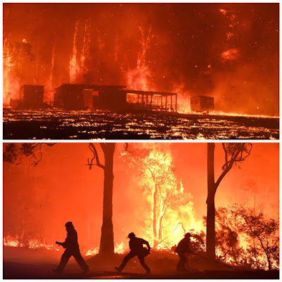
The fire started on November 25, 2019 from a lightning strike and went on to kill three people, destroy hundreds of homes and burn through 500,000 hectares (1.25million acres).
People lived with the threat of this fire until mid February 2020.
We were evacuated for a week but our home was saved due to the bravery of the men and women of the NSW Rural Fire Service with flames coming to within a meter of our house. We lost fences, a machine shed and all our beautiful bushland, since mostly recovered.
The smell of smoke still haunts us and our neighbours today.


