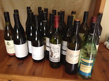
While she was attending classes, I would be scouring the Yarra Valley and Mornington Peninsula wine regions for good examples of Pinot Noir.
Rumour had it that the 2010 vintage for that variety in those regions was the best in years.

It was an early morning start on the road south through some pretty heavy rain.
This is a well known route for us up until Bega where we turned west up over a fog bound Brown Mountain and headed for Jindabyne in the Snowy Mountains. We first crossed the rolling treeless hills of the Monaro High Plain. This is prime sheep country where some of the finest Merino wool in the world is produced. The weather improved on this leg of the journey to allow us to enjoy the vastness of this area.
Our route took us through the small township of Dalgety (once mooted as the site for Australia's capital city) where we crossed the once mighty Snowy River which sadly, due to up stream damming as part of the Snowy Mountains Scheme, has been reduced to a weed filled 'drain' .
The Snowys are the highest point in Australia’s Great Dividing Range which runs down the entire east coast of the country.
Mount Kosciuszko in the Snowys is the highest peak on the Australian mainland at a height of 2228m (7310 ft).
It was named by the Polish explorer Count Paul Edmund Strzelecki in 1840, in honour of the Polish national hero, and hero of the American Revolutionary War, General Tadeusz Kosciusko.
There is a large statue of the explorer on the shores of Lake Jindabyne

A little known fact is that as measurement technology improved it was found the peak originally called Kosciuszko was in fact slightly lower than its neighbour, Mount Townsend.
In typical Australian fashion the names of the mountains were simply swapped by the New South Wales Lands Department, so that Mount Kosciuszko remained the name of the highest peak of Australia with Mount Townsend ranked as second.

Jindabyne and its lake were also pretty much fog bound and after lunch we headed further up the mountain range to spend the night in Thredbo which is one of the many ski resorts in the area. Due to the short ski season in Australia (mid June to mid September, if you are lucky), they are trying to promote the area as a summer resort emphasizing the great mountain walks and the boating and fishing on the lakes.
Unfortunately despite a lovely room at the Snow Goose Apartments which promised spectacular mountain views all we could see was.....fog.
The town was basically deserted. Restaurants open on a nightly rotational basis and we had a nice Brazilian meal with a great bottle of d'Arenberg Grenache.
Next morning with ever increasing rain we headed off on the Alpine Way which crosses the mountains and winds its way into Victoria. I had waited 65 years to see Mt Kosciuszko up close but all we saw was....fog (and a lot of kangaroos feeding by the road side).
So I have taken a picture of the mountain off the net to show it really exists. It's not the most impressive mountain in the world. More of a hill, really and it's a relatively easy walk to the summit via a graded path.

Almost to Khancoban we came across a hydro power station, the first evidence of the Snowy Mountains Scheme.
The Scheme was one of the world's engineering wonders of the 2oth century.
It is a hydroelectricity and irrigation complex which consists of sixteen major dams, seven power stations, a pumping station and 225 km of tunnels, pipelines and aqueducts and was constructed between 1949 and 1974. The water of the Snowy Mountains region is captured at high elevations and diverted inland to the Murray and Murrumbidgee Rivers through two tunnel systems driven through the mountains. The water falls 800m and travels through large hydro-electric power stations which generate peak-load power for south eastern Australia.

The Scheme also secures water flows to the Murray-Darling Basin providing around 2,100 gigalitres of water a year to the irrigated agriculture industry there which is worth about $A3 billion per year ie. 40% of the gross value of the nation's agricultural production.
After coffee in Khancoban were crossed the border into Victoria and headed for Wodonga along the Murray Valley Highway.
It was here that our troubles began.


No comments:
Post a Comment