Wednesday, June 28, 2006

Around and About Tucson

Here are the results of our first few weeks’ travels around the Tucson area.
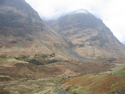
‘A’ Mountain or Sentinel Peak is just a few minutes out of town. The original name of this hill was derived from its function as a lookout point for the Spanish. In 1915, fans of the University of Arizona football team whitewashed a large "A" on its side to celebrate a victory, and the tradition has been kept up ever since. The permanent "A" is now red, white, and blue. The peak is a great place to get an overview of the town's layout as well as have a look at the surrounding desert and mountain ranges.

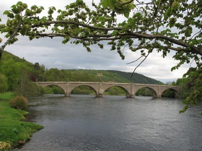
Sabino Canyon lies at the foot of the Santa Catalina Mountains and the entrance is now basically integrated into the north eastern suburbs of Tucson. A sealed road runs six kilometers into the canyon, crossing 9 stone bridges over Sabino Creek. The creek begins 1800m above the desert floor, in the pine forest that shades the slopes of Mt. Lemmon. It winds its way 16km through the mountain canyons before reaching the desert, where much of it eventually sinks into the ground, adding to Tucson's supply of groundwater.
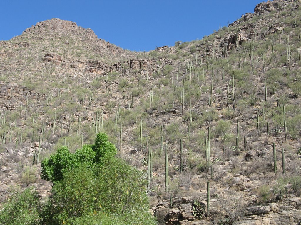
The only motorized vehicles allowed on the road through the canyon are the shuttles which run every half hour, picking up and dropping off passengers at the nine stops along the way. This gives visitors great, if fleeting, views of the creek, the riparian vegetation, Saguaro cactus on the canyon walls and towering rock formations. It is a lot easier than walking, either up or down, in the heat although there were plenty doing just that when we were there. There were even joggers. At 43°C!

Archaic nomads used the canyon area for thousands of years and hunted small game. The earliest visitors were probably of the Clovis culture 12,500 years ago, and later, as the climate changed, the Cochise culture became dominant about 8,000 years ago.
About 1500 years ago, farmers of the Hohokam culture occupied the canyon but they mysteriously disappeared and were replaced by the Pima and Tohono O'odham Indians, who still inhabit the Tucson area today.
European settlement opened up the area further and the canyon was the scene of many conflicts with the indigenous population. A few attempts were made to dam the creek (hence the road) but the various plans were soon abandoned.
Sabino Creek flows 9 to 12 months of the year, making it unique in the Tucson area. The canyon has good examples of riparian and desert flora. Riparian areas have cottonwoods, willow, walnut, sycamore and ash trees. Foothill plants include Mesquite, Palo Verde, Brittlebush, Saguaro and many other cacti.

Animal life is abundant but not always highly visible. Many birds and other mammals have colors that blend into the landscape while other animals are nocturnal and avoid the extreme heat of the day by foraging for food at night. Some animals that are often found in the canyon are the ground squirrels and White-tailed Deer, Mountain Lion, Bobcat, Coyote, Fox, Cactus Wren, Roadrunners, Canyon Tree Frog and Red-spotted Gila Monsters and rattlesnakes. In fact, due to the incursion of the suburbs, mountain lion ‘incidents’ are on the increase. The canyon has been closed on many occasions due to ‘stalking’ and sadly the offending animals have had to be shot.
The visitors’ centre has worthwhile exhibits on the geology, history and biology of the area.
http://www.desertusa.com/azsabino/sabino.html
The Arizona Sonora Desert Museum is to the west of Tucson near the Saguaro National Park. It is a zoo, natural history museum and botanical garden wrapped up in one and covers about 10ha of Sonoran Desert. They exhibit more than 300 animal species including reptiles, mammals and birds as well as 1,200 kinds of naturally growing plants. There are almost 3km of hot dusty paths traversing the desert but there are shelters and iced water fountains (really!) along the routes. I was particular interested in the reptiles and other nasties and they didn’t disappoint with a large collection of rattlesnakes, other snakes, spiders and scorpions, all alive, but behind glass. There was also a nice collection of regional gems, minerals and fossils as well as a great collection of flowering desert plants.

Animals on display included mountain lions, black bears, deer, wolves, coyotes and javelinas. They well all housed under natural looking conditions and although I am not a fan of zoos this was one of the less cruel looking ones. There was also a walk in aviary, an exhibition of living butterflies, hummingbirds and bees. An underwater cave to watch fish, beavers and otters in their natural habitat was also well worth visiting. Anyone who says Australia is a dangerous place to live because of the wildlife should come here. I think we are way down the list!

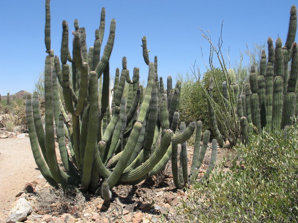
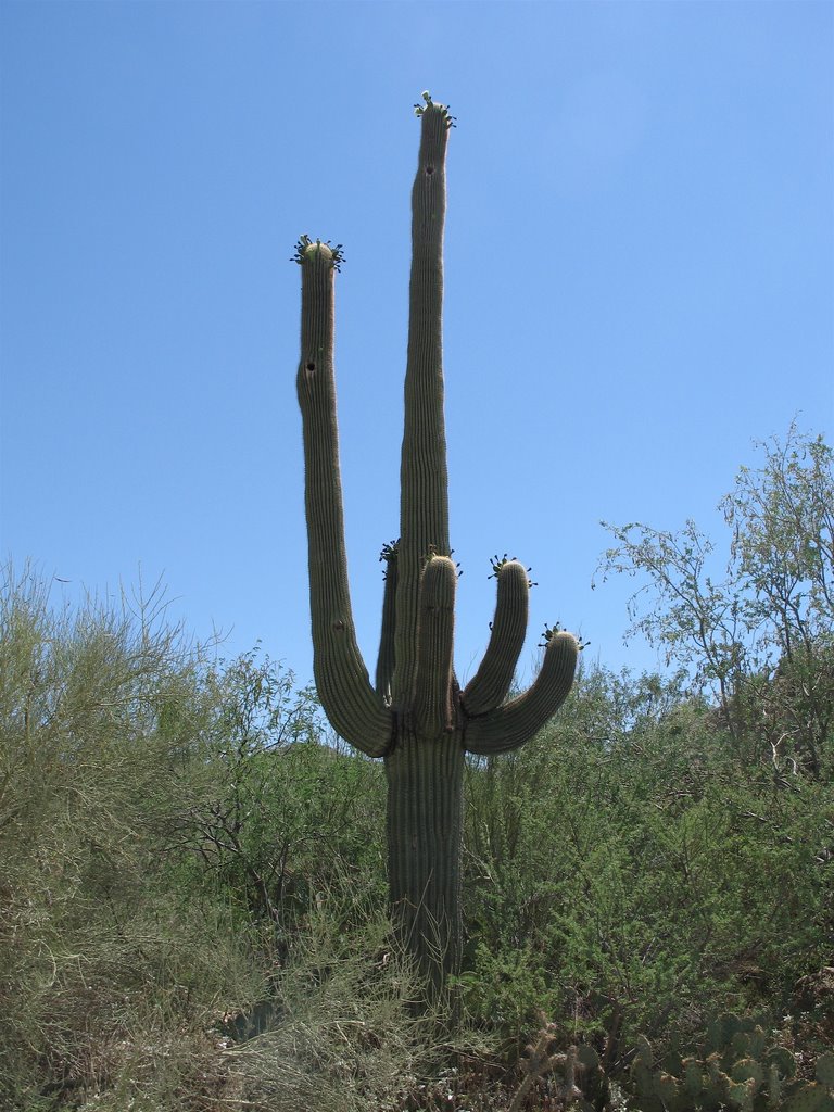
But I guess the highlight is the natural desert with its huge number of plants. I spent a few hours wandering (and sitting in the shade) looking at and reading about these. I especially like the cacti especially the saguaro. Needless to say there were plenty of photos taken.
There are four desert regions in the USA and the museum had set aside part of their area to horticulturally replicate the other three. It is surprising how different the vegetation is and it would be quite easy to know what area you are in by identifying one or two plants. They had also laid down a cactus garden, which supposedly contained every cactus and grass growing in the four regions. All in all a fascinating 3 hours!
http://www.desertmuseum.org/
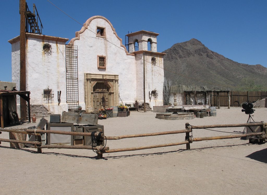
Old Tucson Studios are just down the road from the Desert Museum. They were originally built in 1939 for the movie ‘Arizona’ starring Jean Arthur. There was minimal usage until the 1940’s when ‘The Bells of St. Mary's’ starring Bing Crosby and Ingrid Bergman was made.
During the 1950's, such western classics as ‘Gunfight at the OK Corral’ with Burt Lancaster and Kirk Douglas, ‘The Lone Ranger’ and ‘The Lost City of Gold’ and ‘Cimarron’ (1959) with Glenn Ford were filmed.

John Wayne starred in four movies at Old Tucson Studios and each production added buildings to the town. ‘Rio Bravo’ added a saloon, bank building and doctor's office; from ‘McLintock!’ came the McLintock Hotel; ‘El Dorado’ left a facelift on Front Street; and from ‘Rio Lobo’ came a cantina, a granite lined creek, a jail and Phillip's ranch house.
Other movie productions during those early years include ‘Lilies of the Field’ starring Sidney Poitier, ‘Have Gun Will Travel’; ‘The Outrage’ and ‘Hombre’ with Paul Newman. TV episodes of ‘Bonanza’ and ‘High Chaparral’ were also made there.
In 1971-72 the studio hosted 15 film productions including ‘Dirty Dingus Magee’ with Frank Sinatra and ‘Joe Kidd’ starring Clint Eastwood. Paul Newman returned in ‘The Life and Times of Judge Roy Bean’. Other films during this period include ‘Death Wish’ starring Charles Bronson and ‘The Frisco Kid’ starring Gene Wilder and Harrison Ford, fresh from ‘Star Wars’.
From 1970 to 1980 Old Tucson Studios and its Mescal property hosted 77 film and television productions including, most notably ‘The Three Amigos’ and ‘Little House on the Prairie’, ‘Gunsmoke’, and ‘The Mark of Zorro ’.

The nineties brought ‘Tombstone’, ‘Lightning Jack’ (aaaaahhhhhh!!!!) and ‘The Quick and the Dead’.
All in all this is quite a CV
Unfortunately there was a devastating fire in 1995 and many historic film sets and relics including wardrobe were lost. But is was rebuilt and today the lot is more a theme park than a film set but it is still fun to do the “tour” with a Bill Collins clone who will tell you more than you ever wanted to know about every film made there. I will be watching for the bloopers from now on.
Much of the park was ‘shut down’ due to the season (the temperatures in the dusty streets were brutal). However there were a couple of corny saloon shows, a really good montage of classic western scenes (Westerns were really all the same but who cared) and a really realistic gunfight to finish the day. There was certainly enough going on to fill in three hours.
I decided to head home along Gates Pass Road which leads directly into Tucson rather than take the highway. This was a very spectacular narrow, windy road that snaked through some very beautiful Sonoran Desert countryside.
http://www.oldtucsonstudios.com/
Kitt Peak is a sacred site on the Tohono O'odham Reservation about 90 minutes west of Tucson. The mountain rears just over 1500m out of the desert with a steep 19km climb to the top. The landscape changes as you climb with trees and thick bush taking over from the desert. The 360° view from the top across the desert and other mountain ranges is stunning. At the summit, sits the National Optical Astronomy Observatory, the largest optical observatory in the world with 25 optical and 2 radio telescopes.

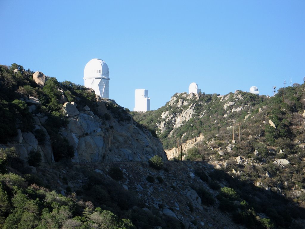
One of particular interest is the McMath-Pierce Solar Telescope. This structure includes a tower nearly 33m in height from which a shaft, parallel to the earth’s axis, slants 60m to the ground. The shaft continues deep into the mountain, forming an underground tunnel where the sun is viewed at the prime focus. It is used mainly for the study of sunspots.
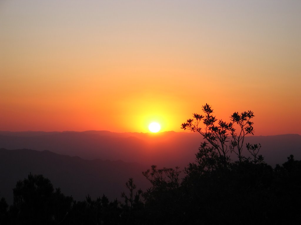
We were told to get there around an hour before sunset when we were we given a nice ‘box’ dinner that we ate outside in the cool evening air (yes, at 2150m above sea level it was finally cool) and got to know some of the other 30 participants. Following that, we were given a brief talk about the observatory, astronomy, the universe and our evening’s program.
Then it was up to “sunset point” where we watched the most amazing sunset and predicted green flash. From there we were divided up into 3 groups and given powerful binoculars for an introductory ‘tour’ of the northern hemisphere heavens. They even predicted exactly when and where we would see a communications satellite traverse in a bright quick flash. Then it was up into the dome for a look through our computer controlled 0.4m optical telescope.

Our instructor was a professional astronomer, full of knowledge, enthusiasm and humor.
Among many things we looked at were Saturn with its rings and one of its moons, Titan, Mercury and Jupiter with the red spot clearly visible. Out of our solar system we saw, M104 (a spiral galaxy with 200 billion suns, 45 million light years away), M51 (a whirlpool galaxy at 38 million light years), M57 (the Ring Nebula, a remnant of a dead star about one light year across and 2,000 light years away) and finally Albireo consisting of two stars, one yellow, one blue that have formed a binary system 410 light years away.
At around 11pm we lined up our cars caravan style to be lead down part of the mountain by a guide, headlights off so as not interfere with the real scientific work that goes on there. This was a bit of a surreal experience seeing how pitch black the desert is but not at all as nerve racking as it sounds.
Kitt Peak is one of the great unsung tourist attractions of Tucson. Even if you don’t think you are interested in astronomy, you could not help being amazed at what you see and learn here. One thing that stood out was how insignificant us earthlings really are in the scheme of things.
http://www.noao.edu/outreach/nop/

Thursday, June 22, 2006

Tucson - First Impressions

The Tucson area has been inhabited for an estimated 3000 years. The Hohokam Indians farmed the area when the Santa Cruz River fed it in the 1st century AD. After they inexplicably disappeared, the Akimel O’odham and Tohono O’odham settled there.
In 1692, Father Eusebio Francisco Kino, the famed Italian priest who served as a missionary for the Spanish church, made the first of many visits to the site, which the native people named ‘Chukshon’ which roughly translated means ‘spring at the foot of the black mountains’.
Present day Tucson was founded on 20th August 1775 by Irishman Hugh O’Connor who served in the Spanish army. He established the legendary walled Presidio San Agustin del Tucson.
Spain’s claim to Tucson ended when Mexico gained independence in 1821. Tucson became part of the United States with the Gadsden Purchase in 1853 and remained so except for a brief period when Confederate soldiers seized the town during the Civil War.
It was once a rowdy frontier town but its reputation was changed by the “civilization” soon brought by train traveling city settlers.
In 1867 Tucson was named the capital of the Arizona Territory however the capital was moved north to Phoenix when Arizona became a state in 1912.

There is one word for Tucson……bleached!
Driving in from the airport the uniqueness of the desert environment is difficult to absorb. Tall and short cactus, sparse undergrowth and straggly trees seem to dominate a landscape that is basically sand and rock. Only after you are here for a while do you learn what a rich environment it really is.
With a population of 900,000, the city sits in the Santa Cruz River valley in the northern Sonoran Desert at an elevation of 730m between five rugged mountain ranges. The most dominant are the Santa Catalinas, just north of the city which rise to over 2750m so it’s quite a spectacular area to live in.
Downtown is a typical modern American city with skyscrapers and wide streets. The city fathers here have tried to improve the ambience of the city centre with parks and squares and “Old Tucson” has been well restored and maintained although sadly the Presidio no longer exists. Some of the older public buildings are quite significant architecturally, especially St. Augustine Cathedral and the Pima County Courthouse.

Suburban architecture ranges from shacks to pseudo adobe Mac mansions in walled enclaves. Lawns are the exception rather than the rule with cultivated desert being the landscape of choice. There is considerable use of gum trees in many gardens, parks and median strips. Because of this we have named one part of a major thoroughfare “homesick row”.

Tucson has around 350 days of sunshine a year with an average maximum temperature of 28C and a minimum of 13C. However it does heat up in summer where maximums are in the high 30’s and low 40’s most days. Humidity is extremely low. Rainfall averages 11 inches a year but for the last ten they have had below average falls. 50% of rainfall comes in the months of July and August during the ‘Mexican Monsoon’ season. This is when moist air from the south hits the heated eastern slopes of the mountains in the morning and rises to condense into clouds which break off in the afternoon to dump their moisture irregularly over the city. Falls can be brief but intense. Flooding, especially along the desert washes, basically dry creek beds that can turn into raging torrents after a downpour is prevalent. Drivers who find themselves caught in these washes are now forced to pay several hundred dollars to be rescued under the aptly named “Stupid Motorist Law’. The rule is to just sit and wait until the water recedes or find another route.
The city is expanding at a great rate with a huge amount of building going on in the Santa Catalina foothills. Water supply is an obvious problem. Most water is piped 400 miles uphill from the Central Arizona Plateau. Serious usage restrictions well known to Sydneysiders are in place.
Tucson is serviced by a large number of shopping malls and strips with all manner of supermarkets, restaurants, cafes and specialty shops. There seems to be, also, an inordinate number of movie theaters but every time we go they are always well attended. The good burgers of Tucson like their snacks at the movies. A mother with two kids in tow made their way to their seats the other day with a swimming pool sized cups of coke and a piled high truckload of popcorn. I waited for the other ten consumers to arrive. The never did! One chain of movie theatres offers a free refill for both coke and popcorn in these sized containers. No one can seem to successfully negotiate the theatre stairs with their booty however. There is always sea of popcorn on them. Maybe that’s where the refills come from.

Live theatre and music are also very popular and there are many art galleries and museums to visit. The University of Arizona has a huge campus which incorporates the main sporting stadium. Golf is a very popular sport and the courses with their green irrigated fairways in the desert setting are very spectacular. But how you play in the heat is a question. As usual the Native American tribes run a number of casinos.
Mexican television is something to behold. We have two channels here. My Spanish is non existent apart from “fill’er up” but flicking through these channels a few programs and World Cup matches have caught my attention. Female presenters are predominantly thin, heavily made up, with big hair who hang (and I mean HANG) out of really colorful dresses all with ragged hems. Males presenters are inevitably older, well rounded with moustaches and are really really jolly. Apart from soccer, the programming is taken up with quiz shows, soap operas, and light entertainment that features plaintive songs accompanied by guitars.
My favorite is a Mexican version of the Jerry Springer Show which is hosted by a tall blond scarecrow who seems to do nothing but scream out “Silencio!” to an obviously rabid audience made up mainly of matronly ladies with justifiable homicide on their minds. It seems that it is standard procedure for a new ‘guest’ entering the stage to physically attack one already sitting there only to be dragged off by two huge African American security guards (but only after some damage has been inflicted). I wish I knew who the criminals are and what their crimes were. But from the reaction of the obviously aggrieved on stage and the hostility of the audience, they must be bad!

Friday, June 16, 2006

Manchester to Sioux Falls, South Dakota, USA

We were delayed a few hours at Manchester Airport by a technical problem but as we had plenty of time to make our connection in Chicago it didn’t really matter. The flight over the Atlantic was very smooth and surprisingly clear. We flew over Harris and Lewis on our climb to altitude and could see quite clearly many of the features, especially the beaches, we had visited a week before.
Even more special was our flight over the southern tip of Greenland. From 10,000m we could see the deep blue ocean with ice flows and icebergs, glaciers, snow capped mountains and the ice sheet. We were unable to take good enough photos but using the resources of Google maps the link below gives you some idea of what we saw. Take time to scroll around.
http://maps.google.com/?ie=UTF8&ll=59.983533,44.391975&spn=0.095663,0.310707&t=k&om=1
We arrived at O’Hare with many other international flights so passage through USA immigration was very slow but we still had plenty of time to make our connection to Sioux Falls.
Our flight was delayed, then delayed again and finally cancelled!
Bad weather in the Chicago area that morning had caused a huge backlog of flights and air traffic control had been forced to reallocate slots. Obviously flights to the main centres took priority.
The airport was full of angry and frustrated passengers, many of whom would have to spend the night there. My partner was quickly on the phone to rebook flights for the next morning, albeit separate ones, while I organized a room at the Airport Hilton. No way was I going to sleep on the floor of the airport! Been there, done that!
This was a very expensive exercise but worth every cent. A hot shower, a comfortable bed and a burger and beer in the bar eased the pain of our delay.
Next morning we were early to check in and soon on our way, together, and upgraded to first class. Thank you United Express!
We headed into town for some lunch, a Caribou Coffee (maybe the best in the world!) and some shopping.
We spent the next few days fighting off jet lag and catching up with family.
We would soon be heading to Tucson, Arizona for an extended stay.

Tuesday, June 13, 2006

Edinburgh to Manchester

From Birnam we drove south east again along back roads towards Stirling and Edinburgh. We soon left the relative remoteness of the mountains and valleys behind as we entered the country’s “city” environments.
Stirling has occupied a key position in Scotland’s struggle for independence. Seven battlefields can be seen from the castle. The Wallace monument at Abbey Craig recalls William Wallace’s (Braveheart) defeat of the English at Stirling Bridge in 1297, foreshadowing Robert the Bruce’s victory in 1314 at Bannockburn.

Stirling is dominated by its castle which is, historically, one of Scotland’s most important fortresses. Legend says that King Arthur took the original castle from the Saxons but there is no evidence of a castle before 1124. The present castle dates from the 15th and 16th centuries and is a fine example of Renaissance architecture.
The castle is a popular tourist attraction but we were early enough to snare a parking place in the forecourt. We wandered through the Palace, the Great Hall and the Chapel Royal as well as along the battlements. There is a lot of restoration work going on here and there is no doubt from what we saw it will be quite a showplace when finished.

There is so much detail to the castle that any cursory description here would do it an injustice so again I revert to a web site for those interested:
http://www.undiscoveredscotland.co.uk/stirling/stirlingcastle/index.html
Next stop was Edinburgh. We had rented an apartment here which was a nice break from a B&B. It was ‘downstairs’ in a Georgian Terrace within walking distance of the main street, Princes Street. It had huge rooms (except the kitchen) with everything you needed and a nice outlook over a back garden. The area had lots of pubs, restaurants and shops including a very nice Italian deli, Valvona & Crolla, within walking distance. Finally we were able to cook our own meals.
Princes Street divides the old town from the new. The Old Town is the site of the ancient city which grew along the route of the Royal Mile from the Castle Rock in the west to the Palace of Holyroodhouse in the east from the 11th century. Building of the New Town began at the end of the 18th century. Castle Rock has, however, been occupied since around 1000 BC.
Next morning we took a cab to the entrance of Edinburgh Castle (well, it was pouring rain and it’s an uphill climb) and armed with our audio guides toured the expanse of this huge complex. The castle has been a fortress, royal palace, military garrison and state prison during its long life. The original fortress was built by 6th century Northumbrian king, Edwin, from whom the city takes its name. We walked the battlements that looked over the ‘new’ city below, wandered through the Palace (with the Stone of Destiny and Scottish Crown Jewels on display), the Great Hall, St. Margaret’s Chapel and the Scottish War Memorial. Outside the chapel stands Mons Meg, a huge siege gun that had been used in many a conflict until exploding during a royal salute to the Duke of York in 1682 when it was retired to the Tower of London. It returned to Edinburgh in 1829.

More details of the castle are available at:
http://www.undiscoveredscotland.co.uk/edinburgh/edinburghcastle/index.html
The Royal Mile is a stretch of four ancient streets which formed the main thoroughfare of medieval Edinburgh, linking the castle to Holyrood Palace. Confined by the city wall, the Old Town grew upwards with some tenements climbing to 20 floors. It’s still possible among the 66 alleys and closes off the main street to sense something of Edinburgh’s medieval past. We did this at Mary Kings Close.
This area consists of a number of closes that were originally narrow streets with houses on either side stretching up to seven floors high. In 1753, the Burgh council decided to develop a new building on the site, The Royal Exchange. The houses at the top of the close were knocked down and the remnants below used as foundations for the new building. These have now been excavated and you are able with the help of a guide walk through these houses and along a medieval street far below current street level. These were once centres of domestic life and industry. Without proper water supply or sanitation, ventilation or daylight, these places were ripe for epidemics. Cholera, typhoid typhus and smallpox were common. Most of its inhabitants were killed by the plague around 1645. A wall in one of the houses was made of a plaster of ground up human bones (every corpse was burnt during the plague) and horsehair.

We walked most of the Royal Mile with its many interesting buildings eg. John Knox’s house, St Giles Cathedral, the City Chambers, among them.
In Edinburgh, there are a large number of shops selling tartan goods especially ties and scarves and I think they do a roaring trade. The Royal Mile is full of them. This trip, I often wore my clan scarf that I bought there last time. There is also a temptation to buy a kilt. So far I have resisted. When would you ever wear one in Australia? Some have been known to don one on special birthdays or maybe weddings but they are certainly rentable at home. I was somewhat surprised to learn from a guide in the castle that all the tartans in use today are not that old and most certainly aren’t ancient. The Disarming Act of 1746, following Culloden, saw to that. For those interested in the history of the tartan check out:
http://www.users.zetnet.co.uk/tartan/history.htm
We had our “big night out” at The Witchery. Their web site states:
Originally built for an Edinburgh merchant in 1595, this historic building on the Royal Mile now includes the jewel-like Witchery dining room …………….
A unique location, stunning interiors and superlative food, wine and service create memorable and magical dining experiences for locals, visitors and celebrities alike. Ewan MacGregor, Michael Douglas, Catherine Zeta Jones, Jack Nicholson and Clarissa Dickson Wright have all succumbed to its charms, with Andrew Lloyd Webber calling it the prettiest restaurant ever!
It is nice to experience restaurants of international reputation occasionally just to find out what all the hype is about. Certainly here, the room, service, wine list and food were outstanding. However we didn’t think the food was anything really exciting. My partner had seared scallops followed by a very large Angus beef fillet. I had pigeon pie followed by what might be called anywhere else, a veal chop. We did have a very nice bottle of premier cru burgundy as well as a totally indulgent chocolate desert.
Prices? We won’t even go there!
Next morning we were back to the Royal Mile, walking this time, for a little last minute shopping and a coffee, then walked down onto Princes street for a look through some department stores, particularly Jenners, and a traditional Scottish pub lunch. We were obviously winding down after three hectic weeks on the road.

Edinburgh is a city with much to see and do. It is a major tourist centre and has wonderful museums and galleries and a widely renowned nightlife. It is also famous for the International Arts Festival and Military Tattoo. But we are not city tourists so leave it you to fill in any gaps you find at:
http://www.undiscoveredscotland.co.uk/edinburgh/edinburgh/index.html
Up early next morning we headed out of town towards Manchester on our pre determined route. The road signage was terrible and we were soon very lost. Instead of the A7 we were on the A1! The UK is so ‘small’ that this doesn’t really matter in the scheme of things and experience has shown if you just keep driving you will eventually find signs that tell you where you are and how to get to where you want to be. So we were soon able to cut across country on narrow lanes and B roads through some beautiful landscape until we reached our first intended destination, Melrose and its historic abbey.
This rose pink ruin is supposed to be one of the more beautiful Border Abbeys. Built by David I in 1136 for the Cistercian monks, replacing a 7th century monastery, it was repeatedly ransacked by English armies. The final blow came in 1545 when Henry VIII, as part of his “rough wooing” policy (where the Scots failed to ratify a marriage between his son and the infant Mary Queen of Scots), destroyed the abbey and, with it, the order.

We explored the ruins for some hours in what was a freezing but sunny day and finally retired to the strangely named (for Scotland) “Pappa Jacks” coffee shop for what turned out to be the best cappos of the trip.
After consulting our maps and time frame we decided we had plenty of time to visit the town, Corbridge, where my daughter had lived for some time last year and then follow Hadrian’s Wall to Carlisle and the M6. So we crossed the border into England and had lunch at one of seven pubs in this old Saxon/Roman town. Then we headed for Hadrian’s Wall.
At the time of Julius Caesar's first small invasion of the south coast of Britain in 55 BC, the British Isles, like much of mainland Europe was inhabited by many Celtic tribes loosely united by a similar language and culture but nevertheless each distinct. He returned the next year and encountered the 4000 war chariots of the Catevellauni in a land "protected by forests and marshes, and filled with a great number of men and cattle." He defeated the Catevellauni and then withdrew, though not before establishing treaties and alliances. Thus began the Roman occupation of Britain.
Nearly 100 years later, in 43 AD, the Emperor Claudius sent Aulus Plautius and about 24,000 soldiers to Britain, this time to establish control under a military presence. Although subjugation of southern Britain proceeded fairly smoothly by a combination of military might and clever diplomacy, and by 79 AD what is now England and Wales were firmly under control, the far North remained a problem. However, the Emperor Vespasian decided that what is now Scotland should also be incorporated into the Roman Empire. Under his instructions the governor of Britain, Julius Agricola, subdued the Southern Scottish tribal clans, the Selgovae, Novantae and Votadini by 81 AD. Further to the North lived loose associations of clans known collectively as the Caledonians. Agricola tried to provoke them into battle by marching an army into the Highlands eventually forcing a battle with the Caledonian leader Calgacus in present day Aberdeenshire at a place called Mons Graupius. 30,000 Caledonians were killed, but the Roman victory was a hollow one, for the next day the surviving clansmen melted away into the hills, and were to remain fiercely resistant and independent.

By the time Hadrian became Emperor in 117 AD the Roman Empire had ceased to expand. Hadrian was concerned to consolidate his boundaries. He visited Britain in 122 AD, and ordered a wall to be built between the Solway Firth in the West and the River Tyne in the east "to separate Romans from Barbarians".
The Roman army numbered amongst its ranks highly skilled architects, mason builders, surveyors and carpenters as well as soldiers for whom the wall was an opportunity to express their talents and also be part of what they felt was the greatest civilising force in the west at that time.
The majority of the wall was built of stone. At first 10 Roman Feet wide, and later 8, it began in the east and reached the river Irthing near present day Carlisle, from there it continues west to the Solway Firth but is built of 18" x 12" x 6" regulation turf blocks.
It’s amazing that some of the 73 mile long wall still exists today.
So our adventure was nearly over. We drove down the M6 in wet, cold and windy weather towards our Manchester Airport hotel to ready ourselves for the trip home the next day. It had been a wonderful trip full of surprises, friendly welcoming people and some amazing sights, both natural and man made. Would we do it all over again?
You betcha!

Birnam and Arbroath

There were two choices of route for our next stop, along the busy A9, skirting the Cairngorms National Park or taking the back roads through it. We chose the latter and really enjoyed the scenery of snow covered mountains and deep glacially formed glens.
The Cairngorms rise to a height of 1300m and, on the back road, seem to completely envelope you. The weather alternated between bright sunshine and torrential downpours so we managed to see the mountains in ‘all seasons’.
We stopped for a coffee break in Braemar (worst cappos in Scotland, maybe the world!) after bypassing Balmoral Castle. Liz and Phil weren’t in residence so we missed out on an invitation for morning tea. At 1100 feet above sea level, Braemar enjoys a scenic location at the meeting point of three passes in Upper Deeside where the Clunie Water flowing north from the Cairnwell joins the upper River Dee. The village gained favour with Queen Victoria and still enjoys royal patronage today.
Braemar is probably best known for its Highland Games, the annual Braemar Gathering which takes place on the first Saturday in September. The games date back over 900 years, to the time when an annual contest between local clans was watched by King Malcolm III. The tradition of royal involvement was resumed by Queen Victoria after her purchase of the nearby Balmoral Estate and successive generations of royals have maintained that tradition ever since.

Then it was on to Glen Shee, the most dramatic and best known of the Angus glens which is dominated by its ski fields. At this time of year they are eerily deserted with the tall towers supporting cables and chairs that are just blowing in the wind. Then it was down the steep Cairnwell Pass, past the delightfully named Spittal of Glenshee and onto greener rural flatlands and a late lunch in Blairgowrie.
We stayed two nights in Birnam just across the River Tay from Dunkeld.
The name Dunkeld comes from the Gaelic for "the fort in the wood". Its recorded history dates back to the foundation here of a settlement by Culdee Monks in about 730AD. This was rebuilt by Kenneth MacAlpin in 848 and two years later Dunkeld became the religious centre of Scotland when St Columba's relics were moved here from Iona for safe keeping from increasing Viking raids. Dunkeld's fortunes up to 1560 were closely linked with those of the cathedral it served: so the destruction wrought by the Reformation that year was a huge setback for the village.

The village was all but destroyed in 1689 in a Jacobite defeat. The houses lining Cathedral Street have been rebuilt and have the reputation for imaginative restoration. The sad ruins of the 14th century cathedral sit in heavily wooded gardens beside the Tay against a backdrop of steep and wooded hills
A bridge linking it with Birnam was built in 1809, when the ubiquitous Thomas Telford produced the solid seven arched structure that is still used today.
Today's Dunkeld is a lovely village of largely whitewashed shops, cottages and hotels.
It was in this area while on holiday that Beatrix Potter found inspiration for her ‘Peter Rabbit’ books.

Birnam tends to be overshadowed by its larger neighbour across the river. Its major claim to fame came from the pen of Shakespeare. According to his telling of the story of Macbeth, it was through the realisation of the witches' prophecy about the movement of Birnam Wood that Macbeth came to his end. Signs in Birnam point you to the Birnam Oak close to the River Tay and behind the Birnam House Hotel. This ancient tree, now supported on crutches, is said to be part of the wood from which Malcolm's soldiers cut branches to disguise their attack on Macbeth at Dunsinane Hill, 15 miles to the southeast. If this seems odd, it is worth remembering that Shakespeare was a dramatist rather than a historian or a geographer.

Next day we visited Glamis Castle on the way to Arbroath. This estate is the birthplace of the current Queen’s late mother. It began as a royal hunting lodge in the 11th century but underwent major reconstruction in the 17th century. It has managed to avoid the ravages of battle, invasion and revolution that have destroyed or damaged many of Scotland’s fine buildings over the centuries and descendants of the original family still live there. Despite this, many of the rooms of the castle, including the Queen Mum’s apartments, are open to visitors.
One of these is the oldest, Duncan’s Hall, which was Shakespeare’s setting for the king’s murder in Macbeth. These rooms present an array of china, paintings, tapestries and furniture spanning 500 years which is stunning. The extensive grounds maintain a commercial herd of the wonderful looking highland cattle.

Arbroath was my father’s hometown and this was my third visit here. His birthplace no longer exists (a victim of ‘progress’) and, to my knowledge, neither does any of the family on either my grandfather or grandmother’s side.
It is an ancient port with origins dating back to Pictish times. It entered recorded history with the founding of Arbroath Abbey in 1174. There was a wooden pier at Arbroath by 1194, and the first harbour, know as the Abbot’s Harbour, dated from 1394. Arbroath's name comes from its position at the mouth of the Brothock Burn: it is a shortened form of Aberbrothock. The town's name has since reached a worldwide stage for two very different reasons.
In April 1320 the Abbot of Arbroath, Bernard de Linton, drafted the Letter of Arbroath, thought by many to be the most important document in Scottish history. This was a letter written to Pope John XXII on behalf of Robert the Bruce, and signed by most of the great and good of 14th Century Scotland. It asked the Pope to put pressure on Edward II of England to recognize Robert as the legitimate King of Scotland; and it also asked him to remove the excommunication that had been placed on Robert after he had murdered the Red Comyn in 1306.
The Letter is famous for one phrase in particular: "as long as a hundred of us remain alive, we shall not on any condition be subjected to English rule”. It continues “It is not for glory nor riches, nor honours that we fight, but for freedom alone, which no good man gives up except with his life".
The Letter was basically Scotland’s “Declaration of Independence” some 456 years before the more famous one. The process of independence continues with Scotland regaining its parliament, albeit with limited powers and responsibilities, in 1999. A bit of a long wait!
Arbroath is also renowned as the home of the Arbroath Smokie. These are pairs of haddock tied at the tails and smoked over burning hardwood chips in 1.5m square barrels. This process still takes place in any number of back street smokeries close to Arbroath's harbour: and the product can be sampled from the many traditional fishmongers still operating in the town. We tried some at lunch and although they look a bit daunting, lightly grilled with lemon butter, they tasted fine.

Arbroath's harbour and its abbey are connected by a largely pedestrianised High Street which with the surrounding town centre offers the full range of shops and civic buildings you’d expect from somewhere with a history quite so long and prestigious. I won’t bother you with a long description of the historic abbey but if you are interested visit.
www.undiscoveredscotland.co.uk/arbroath/arbroathabbey/index.html
Previous visits had given the impression the town was a little dull and worn. But with proceeds from the national lottery, work is being carried out to restore many of the buildings and harbour area to their previous glory. The terrible 50’s and 60’s grey and beige stucco is being removed to reveal the lovely red stone that many of the buildings are constructed of. What were they thinking to cover it up in the first place? My partner visited the Abbey, I wandered the streets and harbour a little, trying to imagine the environment my father had lived in nearly a century ago and wondered at the courage of my grandfather uprooting his family in the early 1920’s and sailing to an unknown country 10,000 miles away.
We headed up the coast to Montrose and then inland to Brechin.
Then it was back to Birnam to ready ourselves for the “big smoke”, Edinburgh.

Sunday, June 11, 2006

Inverness

Stornoway is by far the largest centre on Lewis and Harris and is a bustling and attractive town. The harbor is busy with freight, ferry and leisure traffic, and home to a significant fishing fleet. The shape of the town is defined by the harbor, which partially surrounds it. A number of the streets in the centre are pedestrian only, providing good access to an interesting range of shops pleasantly different from the usual outlets found in most UK High Streets. We had a few hours to kill here so we did some window shopping, pondered my purchase of an entire traditional Scottish outfit (including dagger) for just under $A1700 (negative) and had morning tea. Around town were statues related to its herring fishing roots. Of particular interest were those dedicated to the women packers and gutters. I had watched a program on TV some days earlier called “Worst Jobs in History” hosted by Tony Robinson (of Black Adder fame). Herring gutting was included. He interviewed an old gutter who missed her job (because of the social contact) despite the mess and smell. She could gut 60 herrings a minute!!!!!!!!
Our large Calmac ferry (123 cars and 680 passengers) left for its 3 hour trip to the mainland on time and we headed upstairs for lunch which turned out to be excellent. This was not the most comfortable of trips being a bit lumpy in the open sea.
At 18 knots, Ullapool soon came onto the horizon and we landed on a bleak, cold, wet and windy afternoon. Whatever the weather, you are immediately struck by Ullapool's whiteness and by its design and layout. This is a legacy of the town's origins, being designed and built in 1788 by Thomas Telford* and the British Fisheries Society.
The aim was to exploit a boom in herring fishing at the time. This peaked and then, in an early example of overfishing, declined from the 1830s. By 1900 the enterprise was judged a failure leaving this nice grid plan town with little economic activity and fewer prospects.
It took a couple more decades for the long distance fishing fleets from eastern Scotland and beyond to discover Ullapool's benefits as a safe anchorage on the western side of the country.
Since then, though the fortunes of the Scottish fishing fleet have ebbed and flowed, fishing has remained at the heart of the economy of the town. From the late 1970s - and well before the end of the Cold War - Loch Broom became the base for up to 60 Russian and East European "Klondykers" between August and January each year.
These were factory ships whose role was to process mackerel caught by smaller fishing boats, with the product being transferred to refrigerated vessels for return to home markets. The Klondykers are no longer a feature of Loch Broom, but for many years their crews added a very cosmopolitan air to Ullapool's streets. Today Ullapool remains home to a number of fishing boats.
We stayed at Dronman Guesthouse which was extremely comfortable and had a great lounge/solarium combo overlooking Loch Broom. Dinner was in town at the Seaforth Bar and Restaurant. Only the bar was open (pre tourist season) but we managed a great seafood meal washed down with cold ale. It was here that I saw, for the first time, a great number of servings of steaming haggis being delivered to tables. For the uninitiated, haggis is spiced sheep’s innards (heart, lungs and liver) and oatmeal contained in the sheep’s stomach and boiled for a few hours. We had a few slices fried with breakfast and it wasn’t too bad. I considered a whole one (with turnips of course) for dinner but the poached salmon eventually looked more inviting. Maybe next time!
The rained poured and the wind howled all night.
We went back into town the next morning for some shopping but the weather beat us into submission and we were soon on the road to Inverness.
Near Inverness lies Culloden Moor Battlefield.
Below is the excellent synopsis of the history and background of Culloden taken directly from www.undiscoveredscotland.co.uk It may be a little long but the impact of the eventual failure of the campaign on the history of Scotland is significant and therefore, I feel, makes it worth reading. The potential consequences on world history of Jacobite success is also something to contemplate.
On 16 April 1746 the last battle to be fought on British soil took less than an hour to reach its bloody conclusion here. It was not, as often portrayed, a battle between the Scots and the English: in reality the Scots on the Government side outnumbered those fighting for the Jacobites. Rather it was the last chapter in a sporadic civil war for succession to the throne that had been under way since 1688.

This was the year in which King James VII of Scotland and II of England was deposed in favor of William of Orange by a Protestant nobility fearful he was starting a Catholic dynasty. Efforts to restore the Jacobites to the throne had subsequently led to conflict in 1689, 1708, 1715, and in 1719 when Spanish troops landed in Glen Shiel.
1744 saw the French planning to invade Britain to replace William's successor George II with James II's son, also called James, known to history as the Old Pretender. He would have become James III (and James VIII of Scotland) if the venture succeeded. It didn't: a storm wrecked the French invasion fleet and the French gave up both their plans for an attack on the south coast and a diversionary plan to land a smaller army in Scotland.
Undaunted, the Old Pretender's son, the Young Pretender or Bonnie Prince Charlie, took it upon himself to restore the crown to his father. The following year, 1745, he raised his standard at Glennfinnan. He gathered an army largely of Highlanders, but including some Irish and French troops, to take on the Government. They quickly reached Perth and then Edinburgh before heading south towards London.
The Jacobites reached Derby on 4 December 1745. It was becoming clear that support from English Jacobites was not emerging as Charles as hoped. And it was becoming equally clear that the French were not going to invade in a timescale that would be of any help to Charles' Jacobite army. Meanwhile Government armies were gathering and the military situation looked increasingly bleak. Charles met with his key advisers in what is today the upstairs room of a Derby pub through most of 4 December. Charles was all for pressing on to London: the majority wanted to retreat to Scotland. Charles finally angrily accepted the need to retreat as night fell. The Jacobites began their retreat from Derby on 6 December 1745. What none of them knew was that the Welsh Jacobites has risen in support of them, and others in Oxfordshire were on the point of doing so. Neither did they know that London was in panic and that George II's court was packing his belongings onto ships on the Thames ready to flee to the Continent.
It has been said that had the Jacobites pressed on, George II would have fled; that the English and French would have avoided a further 70 years of conflict; that the English would not have had to raise taxes in the colonies to pay for the French wars; and that the Americans would have had no cause to fight a war for their independence. And, arguably, the French revolution would not have happened. The world might have been a very different place but for a closely argued decision taken in the upstairs room of a pub in Derby one dark winter's evening in December 1745.

Once the retreat was under way, the eventual outcome was probably inevitable as the Government had the time it needed to assemble and marshal its much greater forces. By February 1746, Charles was based in Inverness while the Government forces under the Duke of Cumberland, son of George II, were based in Aberdeen and Dunkeld.
If the outcome after the retreat from Derby was inevitable, the outcome of the Battle of Culloden was doubly so. The Jacobites moved out of their Inverness base on 15 April and assembled on Culloden Moor, five mile to the east. They had succeeded in leaving most of their food and other supplies behind in Inverness. They had also selected for their battlefield ground recorded as "treeless", "boggy" and "bare moor": much more suited to the weapons and tactics of the Government forces than to their own charge and slash approach. The higher ground to the south would have suited them much better.
15 April was the Duke of Cumberland's 25th birthday, and his army spent the day drinking his health at his expense in Nairn while the Jacobites waited, hungry, on Culloden Moor.
As night fell, the Jacobite commanders came up with the idea of marching to Nairn, some 12 miles away, to surprise the drunken Government army. However, by dawn next morning the Jacobites were still two miles short of Nairn, and Government troops were stirring. The Jacobites turned and marched the ten miles back to Culloden.
So when the Jacobite army did finally face the Government army across 500 yards of Culloden Moor at 11am on 16 April 1746, most had not eaten for more than two days; they had endured a pointless forced march and retreat throughout the previous night; and they were on ground ideally suited to the Government army's artillery and dragoons, and totally unsuited to their own single tactic of charging down the enemy.
And they were at a numerical disadvantage. The Jacobites numbered at most 5,000 men, while the Government army facing them was perhaps 8,000 strong, including 800 mounted dragoons. To make matters worse, many of the Jacobites had dispersed in search of food; while others had simply fallen asleep in ditches and buildings. When you add to all of this the much better equipped and trained artillery available to the Government forces, the outcome of the battle was certain before it began.
When the battle commenced, the Government artillery was able to pick off the Jacobites at long range, eventually provoking them into a charge. This reached the Government lines at the southern end of the line of conflict, but was repulsed after savage hand-to-hand conflict. Elsewhere the mass of charging Highlanders did not even reach the Government lines. They were simply stopped by musket and cannon fire before they came close enough to use their main weapons, the spear and the broadsword.
In less than an hour it was all over. 364 Government troops had been killed or wounded. A much larger number of Jacobites and others had been killed during the battle. Many more were killed, as they lay wounded on the battlefield or after being taken prisoner. And the Government dragoons dispatched to hunt down fleeing Jacobites roamed far and wide, indiscriminately killing rebels, bystanders, spectators, residents and anyone else who was within reach. It is estimated that the total dead on the Jacobite side was well over 1,000. A total of 3,470 Jacobites, supporters and others were taken prisoner in the aftermath of Culloden. Of these 120 were executed and 88 died in prison; while 936 were transported to the colonies and 222 more "banished". Many of the rest were eventually released, though the fate of nearly 700 is simply unknown.

So Culloden marked the end of a sporadic civil war for succession that had lasted 60 years. But the brutal reprisals and suppression of the Highlands that followed under the command of the Duke of Cumberland ("Butcher Cumberland") brought about the end of a way of life, and the end of a meaningful clan system. The clan chiefs who survived, or who had supported the Government (and some did), ended up less tribal chiefs than landowners with tenants who might happen to share the same name. The way was thus opened for the Highland clearances that started some decades later, when vast numbers of Highlanders were cleared off their land by the landowners to make room for more profitable sheep. Bonnie Prince Charlie eventually made good his escape to France, but the price of his adventure for the Highlands was high indeed.
As for Culloden Moor itself, the battlefield has over the intervening years been treated almost as badly as the wounded left lying on it at the end of the conflict. The supreme insensitivity came in 1835, when a road was built through the mass graves of the clans. Later the whole area was turned into a conifer plantation.
In more recent years much of the battlefield has been reclaimed, and today there is an excellent visitor centre run by the National Trust for Scotland. Here they have an excellent static historical display and show an excellent and emotive film on the battle.
The conifers that covered the battlefield have been removed; though it still seems much more heavily overgrown than illustrations and accounts show it to have been in April 1746. As a result it still needs an act of imagination to visualize two armies peering at one another across 500 yards of open moorland before the cannon fire of the Government artillery provoked the mass charge of the Jacobites.
We walked the battlefield in drizzly rain towards the Jacobite lines on well worn paths. Strangely no one seems to bother to visit the Government lines. The paths there are overgrown. We passed by the memorial cairn and many mass grave markers of the clans, including one for mixed clans, and eventually looked back from where Charles observed the battle. It was strangely eerie for me as it was the first time I visited here. Although we were alone, I felt we weren’t. Must be a Scottish thing.
We then drove a few miles further on and stopped at the 4000 year old Clava Cairns at Balnuaran.
There are three burial cairns at here and they are part of a line of seven dotted along the south side of the valley of the River Nairn. What sets them apart from other prehistoric burial sites is their construction within a "kerb", a ring of large containing boulders. Clava Cairns come in two types, and both are represented in the group of three you find in the truly wonderful wooded setting at Balnuaran.
The North East and South West Cairns are knows as passage graves. Here the inner chamber remains linked to the outside world by a passage. Both are no more than a metre or so in height, but when originally constructed the cairns are likely to have been around 3m or 10ft in height.

The North East Passage Grave is interesting in having a large number of "cup" marks and some "ring" marks inscribed on one of the kerbstones. Both of the passage graves have a surrounding circle of widely spaced standing stones.
The central cairn at Balnuaran is of the second type of Clava Cairn, a ring cairn. This differs from the other two in having no passageway linking the central camber with the outside. Like the others it is surrounded by a ring of standing stones. One unusual feature is the way that the central cairn is linked to three of its enclosing circle of standing stones by lines of turf covered stones. No one knows their purpose, and it might well be possible that they were added very much later than the date of construction of the cairns. Another later addition is likely to have been the much smaller ring of kerb stones on the north east side of the site not far from the central cairn.
Inverness is a lively city dominated by the Castle, which looks over the fast flowing River Ness. Our B&B looked out over the river too and was very comfortable. There are lots of places to eat out and we found two good ones thanks to our host. Café1 and Rocpool had innovative food, good wine lists and great service. We also came across a second hand bookstore, Leakeys, which is situated in a 1790 Gaelic Church. Good cappos and nice smoked salmon salads as well as over 100,000 books, maps and prints.

The rain had stopped the next morning so we took to the road again along Loch Ness to Fort Augustus. Here, yet another Thomas Telford designed project, the Caledonian Canal which runs from Fort William to Inverness along the Great Glen, lowers (or raises) its customers down (up) a step of 6 locks (some of 29 on the route) to (from) Loch Ness. By then it was a beautiful sunny morning so we sat by the locks with a beer in hand and were lucky enough to see a few boats go through, the ancient swing bridge at the end, opening to hold up traffic on a major highway.
Then it was to our cruise on Loch Ness (a six) and a most enjoyable end to our two days here.
We kept our eyes open and camera out for a Loch Ness monster sighting but none eventuated.
We are not surprised as most of the reported sightings seem to start with the phrase “After drinking in the pub for 12 hours, we ………….”

Friday, June 09, 2006

Lewis and Harris

Sitting in the ferry queue at Uig, the fog began to clear and we were in for yet another fine sunny day. The trip across the Little Minch to Tarbet on Lewis and Harris takes around 90 minutes. It’s pretty smooth sailing with great views. After landing, we headed towards Rodel at the tip of South Harris. The scenery here is amazing. Rocky, treeless hills and mountains and peat bogs. You could be on the moon. These islands are made of some of the oldest rock in the world, some 3000 million years old. Man has lived here for some 6000 years. Gaelic is the language spoken. The dialect in Harris differs from that in Lewis despite the fact it is one island. Gaelic is also the language of the road signs. This could be a bit of a problem if you have an English language map. Then you realize that there is only one main road and all side roads eventually come back to it.

The narrow “highway” winds around the mountains changing from two lane to single-track road at whim. Suddenly we were on the western coast. Wide white sandy beaches with azure blue water stretched into the distance. If the temperature wasn’t 10C you could be in Hawaii. Maybe you would need to plant a few palm trees as well.
Traveling through Leverburgh we ended up in Rodel. This might be the end of Harris but it could also be the end of the world. One lone hotel stood on this barren point looking over the Sound of Harris to the Island of Uist. It was the dourest looking building I have seen. But we took the plunge and went for lunch. Inside was the complete opposite to the exterior. Warm inviting bar and restaurant, good food and beer and very friendly staff. I don’t think they get many tourists down there in May. It was nice to hear the quiet lilting Gaelic language being spoken (except to us). It is in complete contrast to the relative hard Scottish brogue we had become used to.
Buoyed by our lunch and a few beers as well as the fact we were becoming used to the intimidating landscape, we decided to head back to Tarbet via the minor eastern route. Well, the road looked fairly straight on the map.
It wasn’t!
It was the narrowest, twistiest, hilliest and sheep strewn single-track road yet traveled. But the scenery was just WOW! Deep indented sea lochs with their tiny villages were to our right, rocky wind swept peaks to our left (and ewes and lambs in front).
The next day started cold, misty and wet. We drove north over the ‘border’ mountains into Lewis. It’s quite a climb and, on the pass, it started to snow on us. The descent provided even more spectacular views. Taking a B road we drove towards Miaviag passing a field of standing stones and came across some beautiful beaches and seascapes. At random we chose to do a coastal circle road and ended up at a surf beach (possibly called Cliobh) on the Atlantic coast. By now the sun was out but it was a cool 5C. It was time for a beach walk. Then we knew why we had taken our winter coats (plus gloves plus ski cap). The wind chill must have had the temp below zero.

Continuing around the coastline into Loch Rog we came across white sandy beach after sandy beach as well as islands just offshore i.e. within swimming distance if you had a 10mm steamer wetsuit, all with the same white sand and azure blue water.
Notice I am no longer mentioning single-track roads. They were the norm by now and we were handling them well.
Taking another side road we arrived on the Great Bernera, an island just off the mainland. Here they had found evidence of ancient civilizations and had rebuilt an Iron Age house. They had also uncovered evidence of Viking occupation. Those Iron Age dudes knew a thing or two about real estate. The view over Bosta Beach to the outer islands was something.
A major attraction of Lewis is the Callanish Standing Stones. It is considered one of significant and important megalithic complexes in Europe. It consists of rows of large pieces of Lewisian gneiss arranged in a cross shape.
They were erected between 3000 and 4000 years ago and are a complex arrangement of some 50 stones. At their heart is a circle of 13 stones between 8 and 13 feet tall, surrounding the tallest stone on the site, 16 feet high and weighing in at about 5.5 tonnes. Some time later a stone tomb was added to the centre of the circle.
Extending north from the main circle is an avenue formed by a double row of stones, while single rows of stones extend roughly east, west and south from the main circle.
It is thought that the alignments of the various stones were used to mark significant points in the lunar cycle. The stone circle and the north avenue were probably built before 2000BC, while the three single lines and the tomb added around 1500BC.

The site had probably lost its special significance by about 800BC, when a small settlement was built close by. By then climate change had meant peat had been growing across the site for over 500 years and some of the stones were probably already out of sight. The peat was cleared from the site in 1857, by which time it was approaching 6 feet in depth.
Although of huge significance the stones have not always been as well respected as might be expected. One of the stones at the end of the north avenue was broken in the 1860s. The missing tip was later found in a local wall and stuck back in place. Meanwhile a stray stone to the south east of the main circle was set in concrete in the 1860s after being snapped off by a drunk waiting for a boat at the nearby pier.
We had a late lunch at the visitor centre a decided to call it day and make our way back over the mountains to Harris and Scalpay. No snow, just bright sunshine this time.
Sunday is a closed day on Lewis and Harris so you have to make sure the car is filled with petrol and that you stock up on some picnic food on the Saturday. The really mean it too. There was a sign outside the local playground in Scalpay, in English, that said CLOSED ON SUNDAYS!
Because of this we had a dilemma. We had been told that we must go to Huisinis Bay. We still had things to see in Lewis and if we did those Sunday it was possible that they may be closed.
We let the weather decide and as Saturday was fine and sunny we headed for Huisinis.
Our guidebook told us that the B887 to Huisinis is 15 miles of the narrowest and most challenging single-track road we are likely to find again, anywhere in Scotland. And once you get to the other end, and you have had your fill of what's waiting for you there, you have no choice but to turn around and drive the 15 miles back.
The first stretch of road contours around the hillside above Loch a Siar. On the shore below there is the tall brick chimney and the remains of the other buildings of Scotland's last shore-based whaling station at Bunabhainneadar. This was established by the Norwegians in 1904 and purchased with three whaling vessels by Lord Leverhume in 1922 as part of his grand plan for the development of Leverburgh. After his death in 1925 it fell into disuse. A little further on the road passes a rather surreal sight: Bunabhainneadar Tennis Court, built and operated by a sporting charity and available for hire every day of the year (except Sundays). We'd be surprised if there's a tennis court anywhere with a better view.
Prominent in that view to the south is the Island of Taransay, abandoned as unsustainable by is remaining population in 1942. More recently it achieved fame as home in 2000 to a group of people as part of the TV programme "Castaway".
The next surprise en route to Huisinis is the biggest. About ten miles along the road, it mounts a rise and you suddenly find yourself in the front garden of Amhuinnsuidhe Castle. This was built in 1864-7 for the 7th Earl of Dunmore, whose family had brought Harris in the 1830s. The Bulmer cider family owns the castle and the surrounding estate and you can rent it by the week. The road runs right past the front door of the castle before rounding the end of Loch Leosavay and continuing west.

Journey's end is the car park at the east end of the stunning white beach at Huisinis. This is a truly wonderful spot, somewhere to watch the waves breaking or to explore the beach and the surrounding rocks. Huisinis itself is a small collection of cottages and crofts at the west end of the beach, and you approach either along the beach or along the road behind it, which the windblown sand is trying to reclaim for nature. They were right about the road. The 15 miles took us over an hour and caused a sweaty back. Who expected a semi with a bulldozer on the trailer to be using this road!
Huisinis lies at the far end of a neck of land leading to a headland and if you climb the grassy slopes to the north you realise that Amhuinnsuidhe Castle is not quite the final surprise in store on this wonderful journey. Facing you across the half mile wide Sound of Scarp is the island of Scarp. By 1881 clearance elsewhere meant there were 213 people surviving on this beautiful but barren island. But the population fell through the 1900s, the school closed in 1967, the post office in 1969 and the last two families left on 2 December 1971.
Scarp is now best known for a failed attempt to improve the poor inter-island communications that contributed to its demise. On 28 July 1934, the German rocket scientist Gerhard Zucker launched a 14kg solid fuel rocket carrying mail from Huisinis towards its intended destination on Scarp, including a letter written to mark the occasion by the King. Unfortunately the rocket exploded on launch. The scattered and singed mail was collected by the Harris postmaster, marked to record it had been "Damaged by explosion at Scarp, Harris", and delivered by more conventional means. A later rocket fired from Scarp to Huisinis was successful, but the idea never caught on.
We spent a few glorious hours here out of the wind in the sun. Only 4 other cars came and went in that time. Definitely one of the highlights of our trip to Scotland!
After picking up supplies and lunch in Leverburgh, we drove back into the maze of little roads that serviced southeast Harris. Here we found possibly one of the remotest coffee shop and art gallery in the world. Margaret was again the recommender. Set above a small cove with a few crofts and fishing boats we enjoyed a good cappo and fresh scones, jam and cream. They also had internet. VERY SLOW INTERNET! It took me the time limit of 10 minutes just to access and read my email. This area is also the home of the famous Harris Tweed. Unfortunately both cloth and yarn were too expensive for our wallets.
Sunday saw us back over the mountains and on our way to the Butt of Lewis and its impressive lighthouse. The landscape of Lewis is completely different from that of Harris being predominantly rolling heather covered hills and peat bogs. The relative flatness is quite a contrast. They still dig the peat for fuel and piles of it are drying along the road.
This was about as far north as we could go here and would be during this trip. Back along the west coast we came across the single Trussel Stone, at 6m the largest standing stone in Scotland.
The Gearrannan Blackhouse village was closed but we were still able to walk around and spend some time at a very picturesque location. Although people lived in this area of western Lewis in the Iron Age, "modern" settlement here dates back to the 1600s. For over three hundred years people eked out a living here; lived, died, paid their rents, or were quickly evicted if they didn't. The 1886 Crofting Act gave crofters a security of tenure they had never had before and patterns of living and farming changed as a result. The blackhouses seen in Gearrannan today, though seeming much older, date back only to the end of the 1800s.

Perhaps the most remarkable aspect of life in Gearrannan was how far its inhabitants had to go to earn a living. In May 1920, as part of an annual cycle, seven teams of three women from the village left for Stornoway to process fish before following the herring to the east coast of Scotland then down to eastern England, only returning home at the end of the season. In 1934 a team of three sisters from Gearrannan won the title of "Supreme Champions" in Lowestoft for gutting, salting and layering a barrel of herring faster than anyone else. And it wasn't just the village women who were well-traveled: in the 1950s men from Gearrannan could be found in South Georgia in the South Atlantic each year for the whaling season.
Meanwhile life in the village changed only slowly. In Gearrannan, oil lamps were replaced by electricity from 1952, and in the 1960s piped water arrived in the village, though it still had to be fetched from outside taps. This brought to an end the tradition of communal washing of heavier laundry in the loch, with water heated over open fires on the shore. And from 1965 a daily milk delivery started, ending the need to keep a cow and grow the crops to feed it.
By the 1970s those who could leave had left for easier and more modern accommodation nearby and only five residents remained in the blackhouses. In 1974 the last occupants moved out, leaving the blackhouse village to the ghosts of a way of life now gone.

Just down the road we found a pub that was actually open for lunch (thank you tourist guide) and little beyond that the Carloway Broch, an Iron Age fort which dated back about 2000 years.
So it was back to Scalpay for our ‘picnic’ dinner and preparation for our trip to Stornoway to catch the ferry back to the mainland the next morning.
For me Harris and Lewis was one of the most interesting and strangely beautiful places I have ever been to. My Scottish father was right to tell me to go there one day. Pity it took me 30 years to heed his advice.

Tuesday, June 06, 2006

Isle of Skye to Lewis and Harris

It’s a quick 25 minute trip across the Sound of Sleat from Mallaig to Armadale on Skye on a very comfortable Calmac ferry. We drove another 90 minutes along one-track roads in single file with the rest of the cars from the ferry and then, thankfully, on the major north south highway through some pretty stunning country with snow capped mountains, deep valleys, heather covered moors and vast seascapes to Edinbane and our accommodation at the Lodge Hotel.
Built in 1543, this building has had many uses over the centuries including a hunting lodge and coachhouse. It is now a pub with B&B facilities. Not the most modern place we stayed in, but our hosts Hazel and Peter made it like home. The bar with its sprinkling of regulars in the evening, the lounge with its huge peat fueled fire, the great breakfast (with haggis (OK) and black pudding (yuk)) and home cooked dinners made for a comfortable stay. Hazel was a wealth of tourist information and where else would the host race out to the car park with your room key when you arrived back from a day’s sightseeing. It also had a resident ghost which we never saw.

The following day saw blue sky and sunshine and was the day, we were told, to go on the Loch Coruisk boat trip on the ‘Bella Jane’.
We first explored the main town of Portree, a fishing port on a well protected harbor with its Thomas Telford designed pier. Here you can tie your fishing boat up and wait for the tide to go out to do some bottom scraping (of the boat that is). The town itself clings to the surrounding cliffs and is a hive of activity full of hotels, B&B’s and restaurants. The town centre has two main streets built around a nice square. There were the usual smattering of tourist businesses including the ubiquitous Scottish Woollens Shop, potteries and, unusually, a hand made soap and candle shop which managed to open one of our wallets.
After lunch, we drove back down south to Broadford where we picked up some really beautiful naturally dyed silk yarn. Then, on another twisting narrow hilly one-track road complete with wandering sheep without an ounce of road sense, we arrived in Elgol. There we picked up our small boat and motored across open ocean to the loch. This is the Cuillin Hills area of Skye with rugged snow capped mountains rising to a height of over 1000m. Islands at the entrance to the loch were home to a sun basking seal colony. They dropped us off just below a waterfall that drains the loch into the sea and told us they would be back in ninety minutes. Talk about isolation! An ‘on the run’ Bonnie Prince Charlie supposedly said of this place “even the Devil shall not follow me here”. We walked along the loch shore, found a sheltered spot in the sun and sat gazing at the most amazing scenery. Yes, they did come back and get us and after a pretty rough trip back to port, we wound our way back to Portree for a really nice seafood meal and a bottle of Marlborough Sauvignon Blanc which made our hard working New Zealand waitress happy.

Next morning was again bright and sunny, and it was the day to do the northwest circle tour. We drove down the Waternish Peninsula on a single track that leads to Stein, Lusta, Trumpan and other small settlements. Trumpan found its place in history as the site of two separate massacres on a single day in May 1578.
It helps to understand the background. In 1577 some 395 MacDonalds on the Isle of Eigg were killed by raiding MacLeods from Skye. The MacLeods lit a fire in the entrance to the cave in which the MacDonalds were hiding and suffocated them. On the first Sunday in May 1578, MacDonalds from Uist arrived in Ardmore Bay and caught the local population of MacLeods celebrating mass in Trumpan Church. In an act of revenge for Eigg they barred the door of the church and set fire to the thatched roof. All but one of the MacLeods were killed.
The girl who escaped managed to get word of the attack to Dunvagen. More MacLeods quickly arrived in force, capturing the MacDonalds' boats stranded by the retreating tide in Ardmore Bay. They attacked and killed the raiding party. The dead MacDonalds were lined up next to a turf dyke or wall, which was pushed over on top of their bodies. For this reason the Battle of Trumpan is also sometimes called the Battle of the Spoiled Dyke.
The ruined St. Conans church is still there and the view over Ardmore Bay is stunning.

We drove into Dunvegan catching a glimpse of the castle which is the seat of the MacLeod clan and then on to Waterstein with its lighthouse and magnificent views over Moonen Bay. Is it my imagination or were these single-track roads getting narrower and populated by more and sillier sheep?
At Carbost we sat in the beer garden of a loch side pub in brilliant sunshine and had a simple lunch before visiting the Talisker Distillery where a distinctive single malt scotch is made. We were given a tour and had the process explained. Distilleries have lost the human touch these days and are basically factories. Where once this one employed 60 now 6 plus computers do the job. We were also given a dram of the particularly fiery liquid to try. Hmmmmmmm…… a few of these might take the pain out of single-track road driving!
Next day was again bright, warm and sunny! What is going on here? Why did we bring our thick heavy waterproof jackets?
Time to do the northeast circle tour of the Trotternish Peninsula.
As we drove north out of Portree, we became aware of The Storr. This 720m mountain rises above the east-facing cliffs that run down the centre of the peninsula for most of its length. It is almost as if the entire eastern part of Trotternish slipped suddenly at some time in the distant past.

And if The Storr is not dramatic enough, sitting at the foot of its cliffs is a 50m high tooth of rock, the Old Man of Storr, so daunting it remained unclimbed until 1955. The Old Man is part of a weird wonderland of rock scenery and outcrops that lie above and below the cliffs. The road north took us along a coast marked by spectacular rock scenery. There are many stop off points and short walks along this road to enjoy the views. Best of all is Kilt Rock, 200ft high cliffs marked in an almost tartan-like pattern by the rock strata, and with a waterfall tumbling sheer to the pebbled shore below.
The grave of Flora McDonald, the woman who saved Bonnie Prince Charlie from capture by the English, is at Clarin. We stopped to pay our respects and met a couple on tour from Brisbane. They turned out to be friends of friends I grew up with. Small world!!!!!!
There is more to the Flora MacDonald story than her association with Charles.
After he eventually escaped to France, Flora was arrested after one of the boatmen had talked about the strange maid who had traveled with them to Skye. She was imprisoned, first in Dunstaffnage Castle, then in the Tower of London, where she was allowed to live nearby "on parole". Flora's story and her courage gained her much sympathy in London and in 1547 she was allowed to go free.
In 1750 Flora married Allen MacDonald of Kingsburgh. In 1773, like many other Scots, they emigrated, moving to the North Carolina Colony. During the American War of Independence Allen served with the British forces (in common with many other expatriate Scots). He was captured by revolutionaries at the Battle of Moore's Creek Bridge on 27 February 1776. Flora was exiled from the United States to Nova Scotia.
In 1779 Flora returned to Scotland and settled in South Uist amongst her clan. She was joined by Allan after his release in 1783 and they moved to Flodigarry, on the Isle of Skye. Flora died on 4 March 1790. To keep the Jacobite legend strong to the end, it is said that she was buried in a shroud formed of a bedsheet used by Charles. Apparently he never made contact with her again after his escape. The more I get to “know” Charles Edward Stuart, the less time I have for him. Is it treason for a man with 50% Scottish blood running in his veins to say this?

That afternoon, after lunch in Uig, we headed back to Stein and the Stein Inn for a few beers in blazing sunshine by Loch Bay. We stayed well into the evening (it didn’t get dark until 11pm) and it was a perfect end to a great three days on Skye.
Next morning we were up early to catch the ferry to Harris and Lewis. Hazel, the trouper she is, had our breakfast prepared and after our ‘goodbyes’, we set off in the fog back to the port of Uig for more adventure.

Monday, June 05, 2006

Sydney to Isle of Skye

The flights from Sydney to Manchester were long and uneventful. I arrived on time, progressed through immigration and customs without a problem and waited for my partner to arrive from Chicago. We picked up our car, a brand new Vauxhall (Holden) Astra and headed up the M6 towards Windermere. Jetlag and motorways don’t mix too well so it was good to finally get off onto the less hectic country roads. Spring was definitely in the air. The fields were green as green and covered in wild daffodils, the trees were coming into leaf and black faced ewes with their newborn lambs, many twins, were everywhere. We reached our destination in record time despite a few wrong turns and headed for lunch. Good old greasy fish and chips at a chippie.
Then we found the Rockside Guesthouse where we had arranged an early check in and headed up numerous flights of narrow stairs into our attic room (quiet and away from the road) for some sleep. That evening we headed for the pub across the road and consumed a few beers before going back to bed. 9pm was too late for them to serve food.
Of course we woke up at 3am bright and cheerful but were soon put back to sleep by BBC early morning television. There is just so much you want to learn about the blue tit warbler’s mating habits. After a traditional English breakfast we started our Lake Country tour by driving around Coniston Water, scene of Donald Campbell’s demise, in misty rain on some pretty narrow roads that were to be a preview of what was to come in Scotland. Actually, as it turned out, these were freeways in comparison.

We ended up in Levens Hall’s famous gardens which features a topiary garden laid out in 1694. This was a pleasant interlude in clearing skies which got rid of the cobwebs and got us prepared for what was later called a scorcher of a day. 28C!
Back around the shores of Lake Windermere, we arrived in Bowness for lunch. We had been recommended Hole Int’ Wall, a pub built in 1612 and frequented previously by such luminaries as William Wordsworth and Charles Dickens. We had a few pints and a sandwich in the beer garden. By now the sun was streaming down and the Poms were threatening to take their shirts off and show us acres of white skin so we headed to the lake for the traditional holiday lake/river cruise.
We judge these on the basis of the Rhine Cruise being ten points and the Memphis Mississippi River Cruise being zero points. This one scored a five. Pleasant enough but spoiled by Japanese tourists taking pictures of each other taking pictures. After another catch up sleep we went back to Bowness for dinner at another recommendation. This was the Porthole, an Italian restaurant which turned out to be one of the better meals of the trip. We forewent our entree in order to buy a 1st growth St. Emilion to go with our excellent pepper steak (with a sauce to die for). Then we succumbed to dessert.
Then came the bill!
I will not harp on about the prices in the UK, especially when converted back into Australian dollars ($A1 = GBP 0.40) but we were caught a little by surprise. Just a few examples in case you are intending to travel there. Petrol cost $A 2.50L (that’s $US7.50 gal), a pint of beer was $A6-$A7, a pub lunch with a beer was a minimum of $A25 each and a double room with en suite in a STB rated four star B&B averaged $150 a night. I should also mention here that despite the fact that British cooking and, in particular pub food, gets a bit of a bashing, we were more than happy with the variety, freshness and presentation offered, even in the smallest country village. British stodge still exists for the traditionalist but we were never forced to succumb.

Next morning and another sunny day, we drove over the spectacular Kirkstone Pass. Its barrenness and moonscape is in complete contrast to the Lake Country we left behind. However after some easy country driving and great scenery, we were soon back onto the M6 and into Scotland.
Again we hit the country roads and arrived at the medieval Caelaverock Castle built in 1270. It is an archetypical fairy-tale castle with a moat surrounding its red stone towers. Despite being the victim of many sieges, border clashes and its eventual demise in 1640, the structure is still in amazing condition. Almost alone, we were able to climb stairs and enter some rooms with their huge fireplaces and soak up the atmosphere.

Then it was on through Dumfries to New Abbey, with its ruined Sweetheart Abbey on the outskirts, for a pub lunch. The story of the founding of Sweetheart Abbey is said to be testament to the enduring power of love. In 1273 Lady Devorgilla signed a charter establishing a new Cistercian Abbey in memory of her husband, John Balliol, who had died four years earlier.
Lady Devorgilla's love for her departed husband extended to carrying his embalmed heart around with her in an ivory box with enameled silver trimmings. After her death in 1289 she was buried in the sanctuary of the abbey church she had founded, and on her instructions the casket containing her husband's heart was buried beside her. Cheery stuff, huh?
Then followed a spectacular drive along the coast to the artists’ town of Kirkcudbright (pronounced kercoobrie; ok, if you say so!) at the mouth of the River Dee where we spent the night at a really nice B&B, Gladstone House, run by an ex divorce lawyer and his wife. They were amusing company and ran a tight ship. We ‘did’ a couple of pubs and ended up at the Selkirk Arms for a very nice dinner of venison sausage and mash.
Another bright sunny but colder morning saw us on the road to Culzean Castle passing by the famous Turnberry golf links. This castle stands on a cliff edge with panoramic views across the sea to the Isles of Arran and Kintyre. It was built in 16th Century, remodeled in the 1770’s by Robert Adam and restored in the 1970’s. It’s now in the National Trust of Scotland’s hands and is a showcase of Adam’s neo-classical style. I am not big on castle tours but this is one out of the box. Some of the rooms are breathtaking. It was a favorite getaway for General Eisenhower during WW11 and in appreciation of his role in that conflict, he was given the top floor to use at any time of his life.

Back on the road and we skirted Glasgow heading for our next stop at Arrochar. On the way, we visited the much-vaunted village of Luss on Loch Lomond. It turned out to be a Scottish Disneyland whose only redeeming feature was the old church and graveyard.
Our B&B, the Argyll View, sat at the end of Loch Long with spectacular views to the mountains that tower above the water. It was here the weather turned nasty and we thought our luck had run out. A dinner of salmon steaks in a deconsecrated church now restaurant eased the pain.
Next morning it was cold, wet and foggy. We headed north along the shores of Loch Lomond with the 975m peak of Ben Lomond covered in swirling mists. We knew we must be in the highlands. The road signs became bi-lingual with Gaelic on the top.
We climbed up onto Rannoch Moor and sped over this barren rugged landscape finally descending into Glencoe Gorge. Wet, cold and misty is the right weather to be there. Apart from its savage history, the area is famous for its awesome scenery and it did not disappoint. The 1692 massacre takes a back seat. At the NTS visitors centre it was hardly mentioned. We heard though, later, that the MacDonalds still have no time for the Campbells.
Little wonder!

Then it was on through Fort William to the ‘Road to the Isles’ and Malliag and our ferry to Skye. Ben Nevis is in the area but its snowy 1345m peak was not to be seen. Apparently it is in cloud 90% of the year. We stopped along the way at the Glenfinnan Monument which commemorates those who supported Bonnie Prince Charlie in the 1745 Jacobite rebellion and where he first raised his standard. Not far down the road is a cairn marking the spot where he left for France in 1746 with his tail between his legs. This sorry tale of folly which lead to Scottish history being changed forever is better told during our visit to Culloden a few weeks down the track.
This is a very spectacular road along Lochs Eil, Shiel and Eilt before hitting the coast and the sea lochs and the first of the white sandy beaches. We had a roast dinner lunch in a nice restaurant in the tiny village of Arisaig. What this establishment was doing here who knows. Maybe it survives solely from the summer tourist trade.
We were coming across more and more single-track roads. These are roads, some of them main roads, wide enough only for one car, which have passing places strategically located along them, every 100m or so. If you see a car coming you pull over onto one of these to let them past. If someone is tailgating you (usually a local in a white mini van or the postman) you should do the same and let them overtake. Sometimes you don’t see someone coming and you meet at the top of a hill on a blind corner. Then it’s time to decide who will back up. It is customary to give a little wave of thanks to those who stop or a toot for those that pull over. It should also be customary for newbies at this game to wear brown corduroy trousers and have a change of underwear handy. We thought these were a little intimidating but we were blissfully unaware of what Lewis and Harris had in store for us.
Mallaig is a busy fishing and ferry port as well as rail head. The setting is very beautiful with tall cliffs surrounding the harbor and the Isle of Skye in the distance about 25 minutes away by sea. We were early so put the car in the ferry queue and went for a walk around town. Lots of tourist shops, hotels and take aways.
But soon it was time to drive the car into the bowels of the ship and head upstairs for a quiet drink while contemplating the next part of our adventure.
And guess what? The weather was improving!