
The narrow “highway” winds around the mountains changing from two lane to single-track road at whim. Suddenly we were on the western coast. Wide white sandy beaches with azure blue water stretched into the distance. If the temperature wasn’t 10C you could be in Hawaii. Maybe you would need to plant a few palm trees as well.
Traveling through Leverburgh we ended up in Rodel. This might be the end of Harris but it could also be the end of the world. One lone hotel stood on this barren point looking over the Sound of Harris to the Island of Uist. It was the dourest looking building I have seen. But we took the plunge and went for lunch. Inside was the complete opposite to the exterior. Warm inviting bar and restaurant, good food and beer and very friendly staff. I don’t think they get many tourists down there in May. It was nice to hear the quiet lilting Gaelic language being spoken (except to us). It is in complete contrast to the relative hard Scottish brogue we had become used to.
Buoyed by our lunch and a few beers as well as the fact we were becoming used to the intimidating landscape, we decided to head back to Tarbet via the minor eastern route. Well, the road looked fairly straight on the map.
It wasn’t!
It was the narrowest, twistiest, hilliest and sheep strewn single-track road yet traveled. But the scenery was just WOW! Deep indented sea lochs with their tiny villages were to our right, rocky wind swept peaks to our left (and ewes and lambs in front).
The next day started cold, misty and wet. We drove north over the ‘border’ mountains into Lewis. It’s quite a climb and, on the pass, it started to snow on us. The descent provided even more spectacular views. Taking a B road we drove towards Miaviag passing a field of standing stones and came across some beautiful beaches and seascapes. At random we chose to do a coastal circle road and ended up at a surf beach (possibly called Cliobh) on the Atlantic coast. By now the sun was out but it was a cool 5C. It was time for a beach walk. Then we knew why we had taken our winter coats (plus gloves plus ski cap). The wind chill must have had the temp below zero.
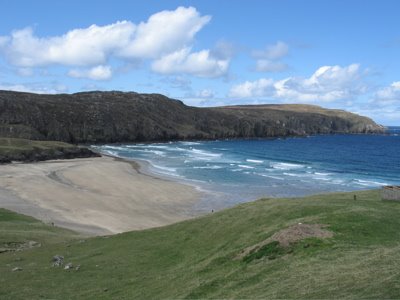
Continuing around the coastline into Loch Rog we came across white sandy beach after sandy beach as well as islands just offshore i.e. within swimming distance if you had a 10mm steamer wetsuit, all with the same white sand and azure blue water.
Notice I am no longer mentioning single-track roads. They were the norm by now and we were handling them well.
Taking another side road we arrived on the Great Bernera, an island just off the mainland. Here they had found evidence of ancient civilizations and had rebuilt an Iron Age house. They had also uncovered evidence of Viking occupation. Those Iron Age dudes knew a thing or two about real estate. The view over Bosta Beach to the outer islands was something.
A major attraction of Lewis is the Callanish Standing Stones. It is considered one of significant and important megalithic complexes in Europe. It consists of rows of large pieces of Lewisian gneiss arranged in a cross shape.
They were erected between 3000 and 4000 years ago and are a complex arrangement of some 50 stones. At their heart is a circle of 13 stones between 8 and 13 feet tall, surrounding the tallest stone on the site, 16 feet high and weighing in at about 5.5 tonnes. Some time later a stone tomb was added to the centre of the circle.
Extending north from the main circle is an avenue formed by a double row of stones, while single rows of stones extend roughly east, west and south from the main circle.
It is thought that the alignments of the various stones were used to mark significant points in the lunar cycle. The stone circle and the north avenue were probably built before 2000BC, while the three single lines and the tomb added around 1500BC.
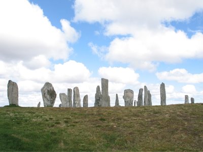
The site had probably lost its special significance by about 800BC, when a small settlement was built close by. By then climate change had meant peat had been growing across the site for over 500 years and some of the stones were probably already out of sight. The peat was cleared from the site in 1857, by which time it was approaching 6 feet in depth.
Although of huge significance the stones have not always been as well respected as might be expected. One of the stones at the end of the north avenue was broken in the 1860s. The missing tip was later found in a local wall and stuck back in place. Meanwhile a stray stone to the south east of the main circle was set in concrete in the 1860s after being snapped off by a drunk waiting for a boat at the nearby pier.
We had a late lunch at the visitor centre a decided to call it day and make our way back over the mountains to Harris and Scalpay. No snow, just bright sunshine this time.
Sunday is a closed day on Lewis and Harris so you have to make sure the car is filled with petrol and that you stock up on some picnic food on the Saturday. The really mean it too. There was a sign outside the local playground in Scalpay, in English, that said CLOSED ON SUNDAYS!
Because of this we had a dilemma. We had been told that we must go to Huisinis Bay. We still had things to see in Lewis and if we did those Sunday it was possible that they may be closed.
We let the weather decide and as Saturday was fine and sunny we headed for Huisinis.
Our guidebook told us that the B887 to Huisinis is 15 miles of the narrowest and most challenging single-track road we are likely to find again, anywhere in Scotland. And once you get to the other end, and you have had your fill of what's waiting for you there, you have no choice but to turn around and drive the 15 miles back.
The first stretch of road contours around the hillside above Loch a Siar. On the shore below there is the tall brick chimney and the remains of the other buildings of Scotland's last shore-based whaling station at Bunabhainneadar. This was established by the Norwegians in 1904 and purchased with three whaling vessels by Lord Leverhume in 1922 as part of his grand plan for the development of Leverburgh. After his death in 1925 it fell into disuse. A little further on the road passes a rather surreal sight: Bunabhainneadar Tennis Court, built and operated by a sporting charity and available for hire every day of the year (except Sundays). We'd be surprised if there's a tennis court anywhere with a better view.
Prominent in that view to the south is the Island of Taransay, abandoned as unsustainable by is remaining population in 1942. More recently it achieved fame as home in 2000 to a group of people as part of the TV programme "Castaway".
The next surprise en route to Huisinis is the biggest. About ten miles along the road, it mounts a rise and you suddenly find yourself in the front garden of Amhuinnsuidhe Castle. This was built in 1864-7 for the 7th Earl of Dunmore, whose family had brought Harris in the 1830s. The Bulmer cider family owns the castle and the surrounding estate and you can rent it by the week. The road runs right past the front door of the castle before rounding the end of Loch Leosavay and continuing west.

Journey's end is the car park at the east end of the stunning white beach at Huisinis. This is a truly wonderful spot, somewhere to watch the waves breaking or to explore the beach and the surrounding rocks. Huisinis itself is a small collection of cottages and crofts at the west end of the beach, and you approach either along the beach or along the road behind it, which the windblown sand is trying to reclaim for nature. They were right about the road. The 15 miles took us over an hour and caused a sweaty back. Who expected a semi with a bulldozer on the trailer to be using this road!
Huisinis lies at the far end of a neck of land leading to a headland and if you climb the grassy slopes to the north you realise that Amhuinnsuidhe Castle is not quite the final surprise in store on this wonderful journey. Facing you across the half mile wide Sound of Scarp is the island of Scarp. By 1881 clearance elsewhere meant there were 213 people surviving on this beautiful but barren island. But the population fell through the 1900s, the school closed in 1967, the post office in 1969 and the last two families left on 2 December 1971.
Scarp is now best known for a failed attempt to improve the poor inter-island communications that contributed to its demise. On 28 July 1934, the German rocket scientist Gerhard Zucker launched a 14kg solid fuel rocket carrying mail from Huisinis towards its intended destination on Scarp, including a letter written to mark the occasion by the King. Unfortunately the rocket exploded on launch. The scattered and singed mail was collected by the Harris postmaster, marked to record it had been "Damaged by explosion at Scarp, Harris", and delivered by more conventional means. A later rocket fired from Scarp to Huisinis was successful, but the idea never caught on.
We spent a few glorious hours here out of the wind in the sun. Only 4 other cars came and went in that time. Definitely one of the highlights of our trip to Scotland!
After picking up supplies and lunch in Leverburgh, we drove back into the maze of little roads that serviced southeast Harris. Here we found possibly one of the remotest coffee shop and art gallery in the world. Margaret was again the recommender. Set above a small cove with a few crofts and fishing boats we enjoyed a good cappo and fresh scones, jam and cream. They also had internet. VERY SLOW INTERNET! It took me the time limit of 10 minutes just to access and read my email. This area is also the home of the famous Harris Tweed. Unfortunately both cloth and yarn were too expensive for our wallets.
Sunday saw us back over the mountains and on our way to the Butt of Lewis and its impressive lighthouse. The landscape of Lewis is completely different from that of Harris being predominantly rolling heather covered hills and peat bogs. The relative flatness is quite a contrast. They still dig the peat for fuel and piles of it are drying along the road.
This was about as far north as we could go here and would be during this trip. Back along the west coast we came across the single Trussel Stone, at 6m the largest standing stone in Scotland.
The Gearrannan Blackhouse village was closed but we were still able to walk around and spend some time at a very picturesque location. Although people lived in this area of western Lewis in the Iron Age, "modern" settlement here dates back to the 1600s. For over three hundred years people eked out a living here; lived, died, paid their rents, or were quickly evicted if they didn't. The 1886 Crofting Act gave crofters a security of tenure they had never had before and patterns of living and farming changed as a result. The blackhouses seen in Gearrannan today, though seeming much older, date back only to the end of the 1800s.
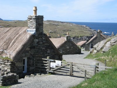
Perhaps the most remarkable aspect of life in Gearrannan was how far its inhabitants had to go to earn a living. In May 1920, as part of an annual cycle, seven teams of three women from the village left for Stornoway to process fish before following the herring to the east coast of Scotland then down to eastern England, only returning home at the end of the season. In 1934 a team of three sisters from Gearrannan won the title of "Supreme Champions" in Lowestoft for gutting, salting and layering a barrel of herring faster than anyone else. And it wasn't just the village women who were well-traveled: in the 1950s men from Gearrannan could be found in South Georgia in the South Atlantic each year for the whaling season.
Meanwhile life in the village changed only slowly. In Gearrannan, oil lamps were replaced by electricity from 1952, and in the 1960s piped water arrived in the village, though it still had to be fetched from outside taps. This brought to an end the tradition of communal washing of heavier laundry in the loch, with water heated over open fires on the shore. And from 1965 a daily milk delivery started, ending the need to keep a cow and grow the crops to feed it.
By the 1970s those who could leave had left for easier and more modern accommodation nearby and only five residents remained in the blackhouses. In 1974 the last occupants moved out, leaving the blackhouse village to the ghosts of a way of life now gone.
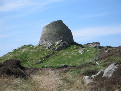
Just down the road we found a pub that was actually open for lunch (thank you tourist guide) and little beyond that the Carloway Broch, an Iron Age fort which dated back about 2000 years.
So it was back to Scalpay for our ‘picnic’ dinner and preparation for our trip to Stornoway to catch the ferry back to the mainland the next morning.
For me Harris and Lewis was one of the most interesting and strangely beautiful places I have ever been to. My Scottish father was right to tell me to go there one day. Pity it took me 30 years to heed his advice.


No comments:
Post a Comment