We stayed at the Yellowstone Village Inn in Gardiner just outside the northern entrance to the park with its famous gate.
This was a quiet little town that basically caters for tourists and we were able to stock up our cooler with ice and goodies at the local supermarket each day for our excursions into the park.
Our first day was spend travelling down the western road to the shores of Lake Yellowstone .
First stop was the Mammoth Hot Springs terraces
These step-like terraces are formed as heated water moves along the Norris-Mammoth Fault. The hot water carries dissolved calcium and bicarbonate to the surface of the terraces where pressure lessens. Carbon dioxide then escapes as gas and the carbonate combines with calcium to precipitate as travertine.
The Terraces are constantly changing shape and color. Springs which were once active may become dry and lifeless but activity can later resume. Along with changes of thermal activity come changes in color. Fresh travertine is bright white in color and on weathering changes to gray. Bright colored cyanobacteria and algae mats which are dependent upon a stable temperature and a flow of water also change as the microorganisms die creating a bleaker landscape.
The Terraces are constantly changing shape and color. Springs which were once active may become dry and lifeless but activity can later resume. Along with changes of thermal activity come changes in color. Fresh travertine is bright white in color and on weathering changes to gray. Bright colored cyanobacteria and algae mats which are dependent upon a stable temperature and a flow of water also change as the microorganisms die creating a bleaker landscape.

One feature of this area was the Liberty Cap, a dormant hot spring cone.
It was formed from a steady flow of hot water emerging from a single source, depositing dense layers of travertine and continued to grow while there was a source of water. Either the hot water spring found a more convenient underground channel to escape through or the orifice became sealed by travertine deposits, so it is now an inactive spring.
We were not specifically looking for animal sightings as we were more interested in the geography but we ran across most on the list except bears and moose. Most elk and mule deer were concentrated around Mammoth Hot Springs township and on our hotel lawn.
We also saw bighorn sheep on the cliffs leading into the park, a lone pronghorn crossed the road in front of us, a small pack of wolves and the odd lonely bull buffalo that seem to take much pleasure in crossing the road halfway and standing there, holding up traffic. We were constantly amused by the large number animal enthusiasts who would miraculously appear at such times with cameras with huge lenses (lens envy was a constant companion in our car) and snap away.
We did however see large herds of bison on the Yellowstone River flats the following day which gave us only a little idea of what things may have been like two centuries ago.
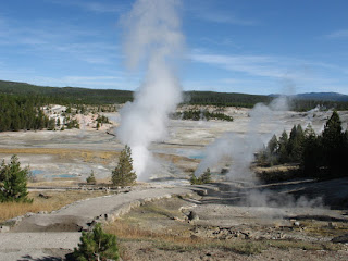
Then we travelled further south past Roaring Mountain (which actually was), to the very edge of the caldera and the Norris geyser basin.
This area is divided into the Porcelain Basin and the Back Basin. The former was our favorite thermal area in the park. A boardwalk traversed the whole area and we were able to walk passed roaring steam vents, gushing geysers, bubbling crystal clear blue pools, rivers of steaming water colored by algae as well as hot springs.
Many of Norris thermal activities release acidic water. Living organisms thrive in the extreme environments of these acid hot springs and the overflow channels of geysers and hot springs are often brightly colored with minerals and microscopic life forms. Hardy, microscopic, lime-green Cyanidium algae thrives in these warm acid waters. Orange cyanobacteria can be found in the runoff streams in Porcelain Basin. From a distance these bacteria look like rusty, iron-rich mineral deposits
Then it was into the caldera where the Gibbon River falls 26m over its edge on the way to meet the Yellowstone and onto the Old Faithful thermal region.
This was the major disappointment of our trip. The area's commercial development and acres of car park are really a blot on the landscape. The old boy himself must have had prostate problems on the day we were there as his 'performance' was pretty mediocre. You got the feeling that the crowd of around 500 gathered on the bleachers for the "show" were as underwhelmed as we were. This must be one of the world's most over rated tourist icons. We couldn't get out of the area quickly enough.
We had a picnic lunch at Scaup Lake surrounded by the ubiquitous lodgepole pine forest with yours truly sitting with his back to the trees pretending to be quite oblivious to the potential for a bear attack. I had left the car unlocked and the escape route mapped out in my mind, however, just in case. It didn't help that the co driver was continually asking "what's that noise?" while looking out into the bush. She will pay.....later!
Then it was over the 2500m Craig Pass and onto the shore of Lake Yellowstone. This is a really beautiful area with the azure blue lake dominating the landscape.
Time to turn around and head back to Gardiner, calling into all the detours we had noticed on the way down including Kepler Cascades, the Firehole River Canyon and Firehole Lake Drive with its many geysers and the amazingly blue and bubbling Firehole Spring.

After a very early dinner we fell into bed exhausted and wondering what tomorrow would bring.
Next morning dawned bright and clear. I should point out here we had taken our winter clothes and an ice scraper as we had been warned of the possibility of fickle autumn weather in the area.
Well it was in the high 20's/low 30's after a fairly cool start most of the time so our winter gear was definitely excess baggage. The Aspens must have known things would be ok. They hadn't even bothered to start to change color yet.
This time we headed down the east road to Tower Fall.

We took what was described as an incredibly rough (read: normal Australian country road) detour on the Blacktail Plateau Drive in the hope of seeing a bear or two. Others had the same idea. I guess the convoy scared off any wild life. We did see a petrified redwood though, the remnant of a time past when the area was sub tropical and before a huge volcanic eruption turned it to stone 50 million years ago.
After viewing the falls (there are 290 in the park) we climbed back over the caldera via the 2700m Dunraven Pass and headed for Canyon Village.
Here the Yellowstone River drops down into the the Grand Canyon of the Yellowstone first via the 33m upper falls, then the 94m lower falls. Your first stop is right on top of the upper falls to watch it go over the precipice. The noise is deafening.

Then across the river you can get a more conventional view. We walked down part of Uncle Toms Trail to get a view of the canyon itself. The trail goes onto the bottom of the lower falls but the signs warning of the difficulty of the climb put us off a bit.

So instead we headed off to Artists Point for what is considered the classic view of the lower falls and the canyon.
We were not disappointed.

From here we drove along the Hayden Valley where the Yellowstone meanders quietly through meadow like terrain after leaving its source lake. Plenty of buffalo and the odd wolf were to be seen.
Then we came across another thermal area. This one had boiling mud pools and sulphur cauldrons which not only were hot but had a pH of 1.0. Falling in would not have been pleasant. You could even see thermal activity in the river that flowed below us.

Arriving at the lake we turned east and followed the shore for quite a way until we started the climb over the Sylvan Pass and exited the park through the East Entrance. From there it was quite a pleasant drive east to Cody.
Our Yellowstone adventure was over.

After a very early dinner we fell into bed exhausted and wondering what tomorrow would bring.
Next morning dawned bright and clear. I should point out here we had taken our winter clothes and an ice scraper as we had been warned of the possibility of fickle autumn weather in the area.
Well it was in the high 20's/low 30's after a fairly cool start most of the time so our winter gear was definitely excess baggage. The Aspens must have known things would be ok. They hadn't even bothered to start to change color yet.
This time we headed down the east road to Tower Fall.

We took what was described as an incredibly rough (read: normal Australian country road) detour on the Blacktail Plateau Drive in the hope of seeing a bear or two. Others had the same idea. I guess the convoy scared off any wild life. We did see a petrified redwood though, the remnant of a time past when the area was sub tropical and before a huge volcanic eruption turned it to stone 50 million years ago.
After viewing the falls (there are 290 in the park) we climbed back over the caldera via the 2700m Dunraven Pass and headed for Canyon Village.
Here the Yellowstone River drops down into the the Grand Canyon of the Yellowstone first via the 33m upper falls, then the 94m lower falls. Your first stop is right on top of the upper falls to watch it go over the precipice. The noise is deafening.

Then across the river you can get a more conventional view. We walked down part of Uncle Toms Trail to get a view of the canyon itself. The trail goes onto the bottom of the lower falls but the signs warning of the difficulty of the climb put us off a bit.

So instead we headed off to Artists Point for what is considered the classic view of the lower falls and the canyon.
We were not disappointed.

From here we drove along the Hayden Valley where the Yellowstone meanders quietly through meadow like terrain after leaving its source lake. Plenty of buffalo and the odd wolf were to be seen.
Then we came across another thermal area. This one had boiling mud pools and sulphur cauldrons which not only were hot but had a pH of 1.0. Falling in would not have been pleasant. You could even see thermal activity in the river that flowed below us.

Arriving at the lake we turned east and followed the shore for quite a way until we started the climb over the Sylvan Pass and exited the park through the East Entrance. From there it was quite a pleasant drive east to Cody.
Our Yellowstone adventure was over.


No comments:
Post a Comment