
It is an ancient landscape moulded by hundreds of millions of years of geological activity.
Scientists believe that the Flinders Ranges began to form about 800 million years ago when a great depression, known as the Adelaide Geosyncline, developed as the earth's crust stretched and thinned. The sea flooded in and, for 300 million years, huge amounts of rock debris, stripped from the land was deposited in the deepening depression to thicknesses of many kilometres.
About 500 million years ago the rock layers were squeezed and folded into a long mountain chain, much higher than today's ranges. The great bulk of the ancestral Flinders Ranges was then eroded over millions of years. Resistant quartzite now forms the highest peaks and ridges of the Flinders Ranges while the softer mudstone, siltstone and shale have been worn away to form valleys and gorges. Occasional earth tremors today indicate that the mountains continue to be uplifted. In fact a day after we left an earthquake of magnitude 4.3 shook Quorn. This plus the fact that some unknown local had won $17 million in the lottery was probably the most excitement this three pub town had experienced for years.

Most evident on the way up were the remnants of old stone homesteads, most in ruin, evidence of failed agricultural enterprises over the past 150 years caused by European farming practices, usually overstocking and over cultivation, and the inevitable long term droughts so common to the area. They also ignored Goyder’s Line which in 1865 indicated potential agricultural disaster for anything other than light grazing north of it.

We stayed at Rawnsley Park. This is a 12000ha (30000 acre) working sheep station that produces meat and wool from 2000 animals. In 1968 they started to diversify into tourism with a caravan park and camping ground and have since extended this to holiday units and eco-villas. We chose the latter. These sit on a low ridge among the native pines and look out onto the southern wall of Wilpena Pound, predominantly Rawnsley Bluff, on one side and the Chase Range on the other.

And what a view from the wrap around verandahs.

And that evening we experienced some pretty spectacular sunset affects on the mountains surrounding us.


The range’s most famous landmark is Wilpena Pound, a large, sickle-shaped, natural amphitheatre covering nearly 80sq km (31 sq.mi) and containing the highest point, St Mary Peak rising to 1170m (3860 ft).
It is impossible to get a total picture of this other than from the air and as our budget didn’t extend to joy flights, I have ‘lifted’ a picture from the net. Thanks lonelyplanet.com

It is impossible to get a total picture of this other than from the air and as our budget didn’t extend to joy flights, I have ‘lifted’ a picture from the net. Thanks lonelyplanet.com

The following morning it was time to start exploring. We headed into the National Park and took the dirt road towards the spectacular escarpment that leads to the starting point of a track that climbs partway up it to Arkaroo Rock.

It was a steady but relatively easy climb up a rocky walking trail on a cool winter's morning through the bush with spectacular views appearing at every turn. After about an hour we reached our goal.

Arkaroo Rock is an important site for the original inhabitants of this area, the Adnyamathanha people. It depicts the formation of Wilpena Pound. There are many paintings here on the underside of a huge overhanging rock including bird tracks, snake lines, waterholes and people created in red, yellow and white ochre and charcoal. They are either drawn using dry pigments that were brushed or applied by finger or using wet pigments mixed with water, animal fat or blood.The site has been dated as 5 to 6000 years old.


It was nice to sit a while there alone in this magic place.
Back on the road again we came across some local wildlife. We had seen plenty from a distance on the journey so far but those around Wilpena seemed oblivious to visitors.


Our hosts had recommended the Bunyeroo Gorge circuit drive so we made the turn onto what looked a pretty good road but it deteriorated somewhat as we got further along it. However the views and the country were so beautiful we drove on.


Our hosts had recommended the Bunyeroo Gorge circuit drive so we made the turn onto what looked a pretty good road but it deteriorated somewhat as we got further along it. However the views and the country were so beautiful we drove on.
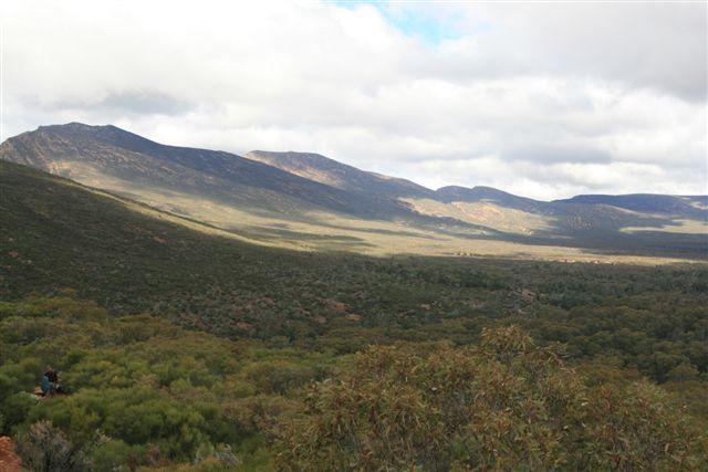
Initially the drive is through grassy plains, covered with native pines and surrounded by bare hills. Within a few kilometres, the purple peaks of the distant ABC Range are the dominant feature.

Then there is a very steep descent down into Bunyeroo Gorge. Once down into Bunyeroo Creek, you actually drive up the creek bed, which has been carved out of the ABC Range over 590 million years. There was some water in it but not flowing and I was glad I had the low ratio all wheel drive and extra clearance of the Forester at this stage.

Emerging from Bunyeroo Creek, the road enters the Wilcolo Creek Valley and there is now a dramatic change in scenery. Immensely steep hills, sheer gullies and pyramid peaks, with the Heysen Range on the left and the ABC Range on the right, with dense stands of native pines and giant River Red Gums and many small creeks to cross. Luckily for us they were mainly dry although one nearly had us out walking it before risking the drive through.
It was here we decided to have lunch. Another magic spot.

After another 20km or so we were back into open and flat country with the vegetation changing from open scrub back to native pines. After passing through one last creek, we came to a T junction. The Brachina Gorge or the Sacred Canyon? The latter won out.
Another dirt road but a reasonable one. Emus and kangaroos were everywhere.


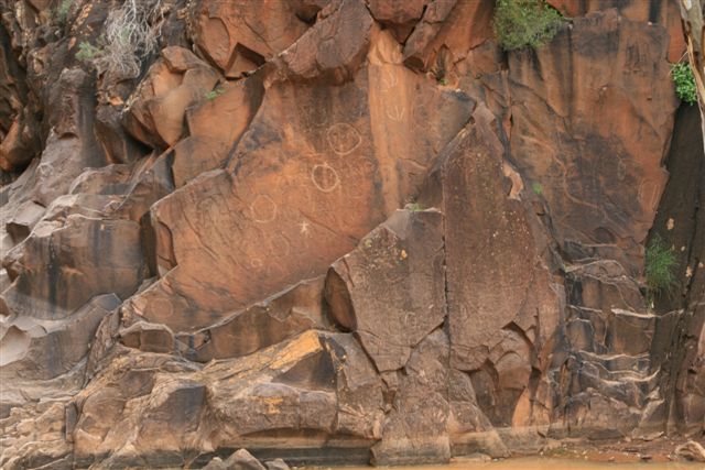
From the car park it was a rather difficult walk along a gum lined dry creek bed that got somewhat narrow. Then we came across quite a deep waterhole that needed a detour climb up the canyon walls a little way.

Finally we came to a small amphitheatre that is obviously at the bottom of a raging waterfall during wet times. There on the smooth sandstone walls we saw the ancient Aboriginal rock engravings which had been pecked onto the rock with stone tools. They represented animal tracks, people and waterholes. Many are very weathered and difficult to pick out but it was worth the effort.

At the end of an exhausting day it was great to get back to the comfort of our cabin, cook a meal and enjoy a bottle (or two) of our Clare Valley purchases.
That night the heavens opened up with torrential rain and we were witness to a great lightning and thunder show.
While we appreciated that the locals were pretty happy about this, the next morning we awoke to find it still raining and ourselves fogged in. Is this really a desert after all?


We were resigned to the fact we had come all this way and the exploration of the Pound itself would be denied us. Part of travel we rationalised so out came the books and CD's. Within two hours the rain had stopped and the fog began to lift and we made a bee line for the Pound.
Obviously others had not been so optimistic. The ranger station was basically deserted apart from staff.

There is only one way to get into the Pound and that is to walk. And it is quite a way along the beautiful River Red Gum lined (and dry despite the rain) Wilpena Creek until you get to a narrow opening, Sliding Rock, cut by the creek through the 'wall' of the Pound. A slight climb and you are inside. There the original Hill homestead has been reconstructed with a history of the place, "Jessie's Story", reproduced in plaques. It is a story of hard work and heartbreak in a tough environment but one that reflects others in the region. I had thought that this may be available somewhere on the net but it is not. Luckily someone has photographed the plaques. They are worth a read.
http://www.pbase.com/lambsfeathers/jessie

http://www.pbase.com/lambsfeathers/jessie

Walks continue all over the inside of the Pound but we were interested in climbing up to the top to Wangarra Lookout. 'Only 800m' said the sign but it forgot to mention the thirty degree slope. Really good for walking off the previous meals and wine as well as testing the heart.
At the base of the track there is a sculpture of Aborigines pointing the way with the legend of the formation of Wilpena on the back.


..................(click on image to enlarge)
We both took it very easy climbing up the steep and sometimes quite slippery rock pathway, stopping from time to time enjoy the ever increasing panorama (and catch our breath).
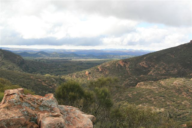
At the top, the view was amazing and well worth the climb.
We looked into and across the pound and.......

back over to the gap in the escarpment from where we had come through.

We enjoyed the solitude for some time and then made our way down, passing a lot of late starting 'puffers' on their way up.

back over to the gap in the escarpment from where we had come through.
We enjoyed the solitude for some time and then made our way down, passing a lot of late starting 'puffers' on their way up.
Back at the old homestead we sat and enjoyed a long picnic lunch in the sun with a friend.

Then it was a leisurely stroll back to civilisation on an alternate route along a tributory of the creek, that had billabongs filled with water from the previous night's rain, for a coffee at the ranger station cafe' and a warm up in front of a fire.

What a great day! An item on my bucket list crossed off and a far better experience than ever expected.
Needless to say we fell into bed quite exhausted but did have time for a farewell BBQ and a good bottle of red to celebrate our mountaineering prowess.

Next morning we were up early and, after saying 'goodbye' to our favourite huge river gum standing in the dry creek bed at the entrance to Rawnsley Park, we headed back down the highway for the long drive to Adelaide.


No comments:
Post a Comment