The heavy rains forecast statewide this weekend will bring an end to what was already the least active bush fire season in a decade.
NSW has recorded fires in just one per cent of the area burnt in the record 2019-20 season, the Rural Fire Service said.
Severe weather and flood warnings have been issued for parts of New South Wales.
Our area is likely to receive 100-200 millimetres between today and the weekend, with the heaviest falls likely on Saturday.
The burst of autumn rain comes as the La Nina weather pattern in the Pacific “is on its last legs”.
Sea-surface temperatures are back in a neutral range but the atmosphere is still in a mode favouring wetter-than-average conditions for eastern NSW into April.
The soaking rains mean that the fire season will officially come to an end on 31st March.
It’s the first time for a long time, there has been no extensions of fire restrictions anywhere in NSW.
It’s the quietest fire season since 2010-11.
Figures compiled by the Rural Fire Service show that, between July 1 and the end of February, the area burnt in the state was 57,138 hectares, or just 1 per cent of the 5,490,504 hectares burnt during the comparable period in the previous year.
There were 5132 fires or fewer than half the tally of 11,482 a year earlier.
In the 2020-21 fire season to date, there have been no Class 3, or Section 44 bush fires that
trigger a so-called bushfire emergency.
That’s also the first time a decade without one.
Good news!
Update: 20th March
Towns along the NSW North Coast, including Port Macquarie and Taree were inundated by floodwaters today as rivers broke their banks.Huge amounts of rain fell in the region between 9am on Friday and 5am on Saturday, including 373mm at Delward, 343mm at Redoak (Stewarts River), 320mm at Logans Crossing, 280mm at Kindee Bridge, and 264mm at Wauchope. (250mm = 10 inches)

So far in our area we are experiencing fairly strong winds but have only received 40mm rain.
However the system is moving south and we could see substantial falls overnight.
Wet weather is expected to continue battering the state until mid-next week.
Update: 21st March
The deluge continues.
We have had another 40mm.
However things are much worse to our north.
Western suburbs of Sydney are being evacuated as the city’s main water supply dam overflows. This is now considered a 1 in 50 year event.


Virtually the whole of New South Wales is being affected by this system. No relief from the rain is expected until Wednesday.
Update: 22nd March
The Bureau of Meteorology has updated its severe weather warning, with heavy rainfall stretching from the Northern Rivers to the South Coast tomorrow.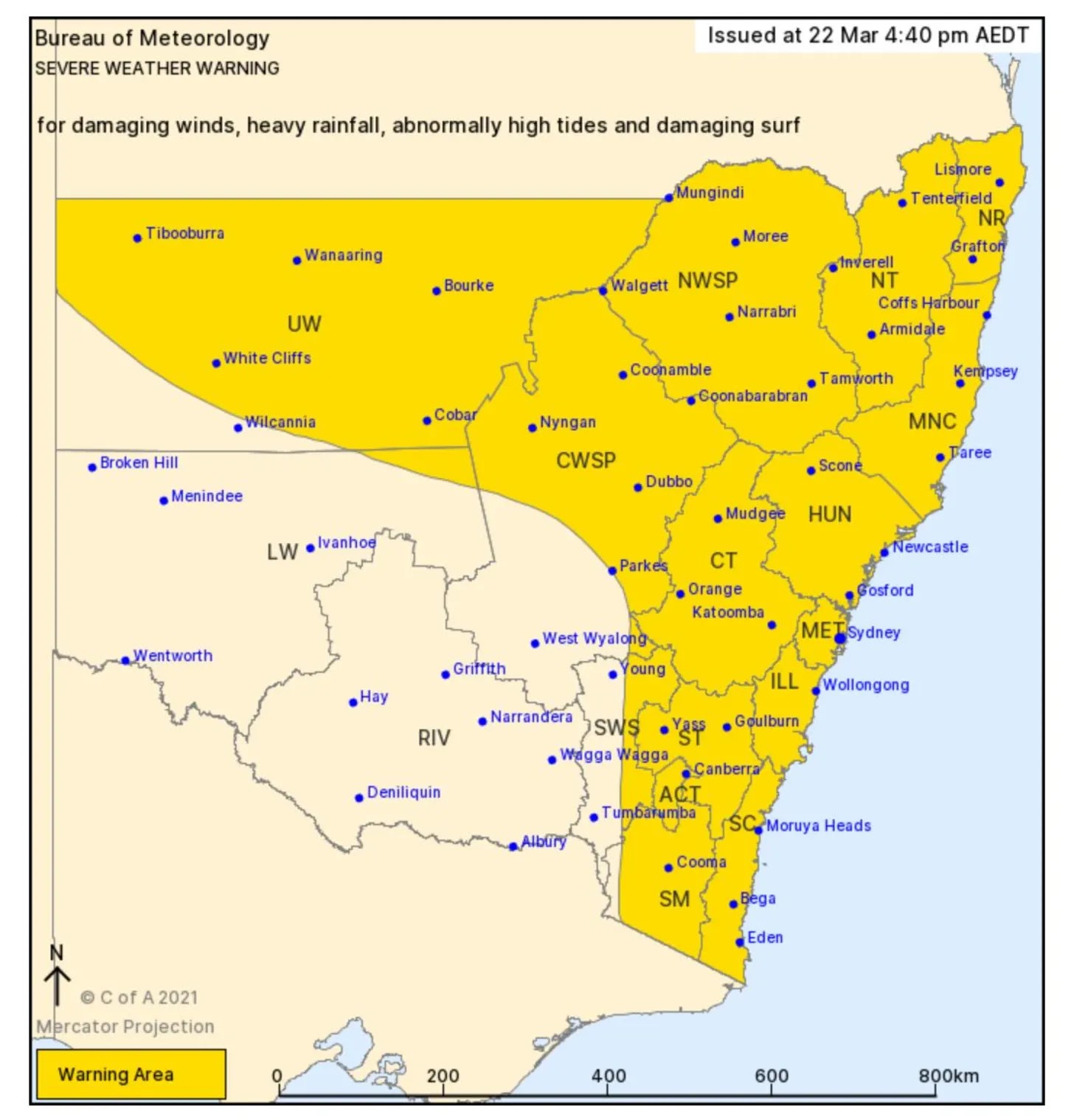
Heavy rainfall will then extend to areas of the ACT, South Coast, Snowy Mountains and Northern Tablelands during Tuesday. There is an enhanced risk with any thunderstorm activity.
That’s us in the south.
Update: 23rd March
The rain has finally stopped.
We had just over 50mm today making a total of 200mm (8 inches) over 4 days.
We got off pretty lightly compared to others.


Our creek is up and flooding and we’ll have some fencing damage but it will be minor.
This was a huge weather system covering an area the size of Alaska.
For some it was a 1 in 100 year event.
Update: 24th March
There are sunny blue skies today but the flood waters out west and along the mid-north coast have not yet receded.
There are sunny blue skies today but the flood waters out west and along the mid-north coast have not yet receded.
Fifteen thousand people remain on alert to evacuate and 18,000 people have already evacuated.


As of this morning more than 950 people have been rescued from flood waters by the State Emergency Service, which has received more than 11,000 calls for help. Some 280 schools remain closed and 9,500 claims have been lodged with insurance companies.
So we will finalise this post here unless something drastic happens in the meantime.
So we will finalise this post here unless something drastic happens in the meantime.


No comments:
Post a Comment