As a result of global warming, climate change has created scenarios where dangerous weather events have become more frequent or severe.
This summer in eastern Australia, a severe weather event resulted in record flooding. This follows the disastrous drought and heat induced bushfires of 2019/20.
However it seems the severe wet weather is not over yet.
The Bureau of Meteorology has urged residents in flood-prone areas to remain vigilant as an estimated 100mm is set to fall along the NSW coast, including Sydney, from late today (Wednesday) in a weather event that could lead to flash flooding.
More than 150mm of rain is predicted over the seven days until next Wednesday from about the Illawarra region (that’s us) to Moreton Island in Queensland.
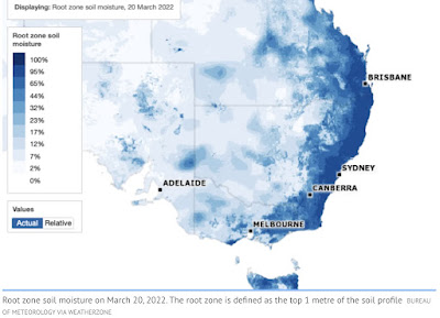
Rivers and water catchments across the state’s east coast have not had enough time to dry out since the flood emergency at the start of the month, and therefore are at greater flood risk, even with a small amount of rain. The root zone soil map below shows how saturated the east coast is.
Meanwhile, the wet weather looks set to linger until later this year with trade winds still stronger than average in the western Pacific, delaying the weakening of the weather system.
Update: 30th March
And so the predictions have come to pass, but even worse than envisaged.
The Northern Rivers district only a few weeks ago devasted by floods, is having to cope with more. The town of Lismore is being evacuated again as waters top the levees.
We have no idea how much rain has fallen there as the weather station was destroyed in the last flood.
That’s around a total of 1400mm (55 inches) in the last two months.
And it continues to rain the entire east coast from Brisbane to the Victorian border.
We here have had more than our annual rainfall in 3 months ie. +1000mm or 39 inches.


.png)


No comments:
Post a Comment